Top 10 Sites of 2019!

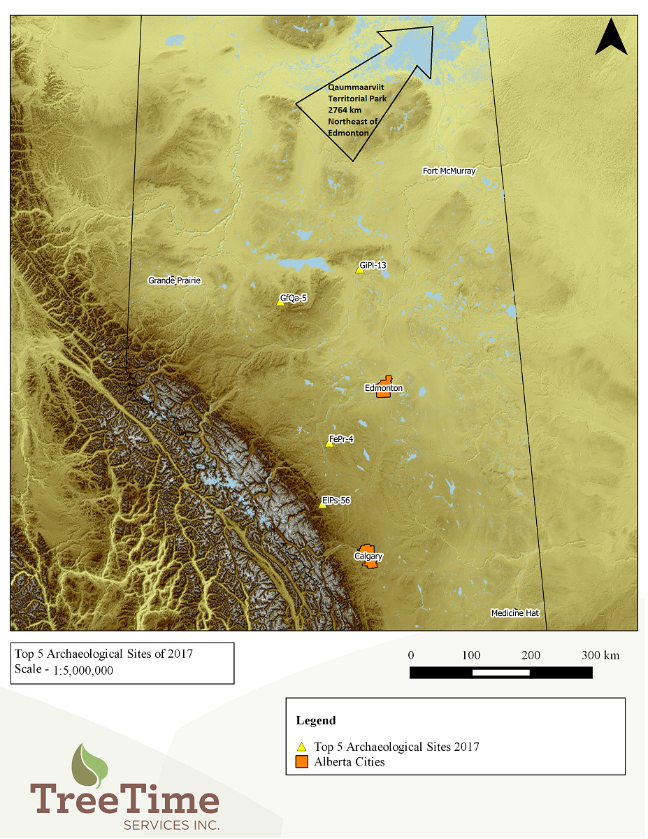
We are heading into the fall of 2020 and the season crunch is in full swing! We have been pretty busy, despite the challenges of COVID-19, and have found quite a few new and exciting sites. This makes us recall the sites of 2019! It was hard to make time to write up what we found in 2019. Although we find over 100 sites every year, these sites stand out either because we found interesting artifacts or the site is unique in some way.

Locations of the Top Ten Sites of 2019

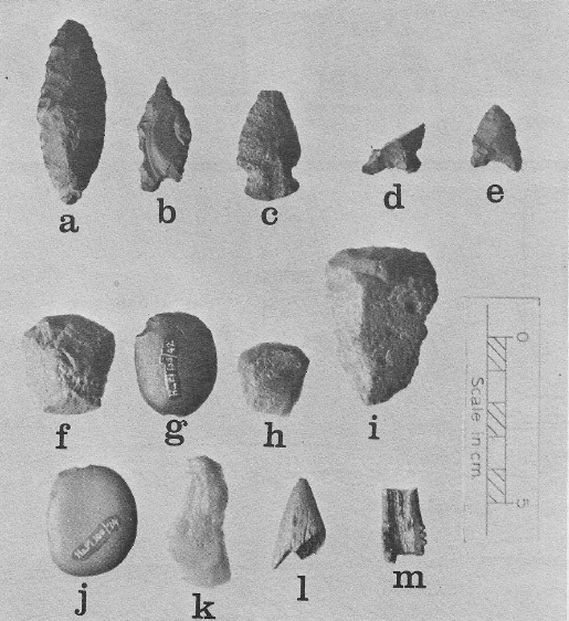
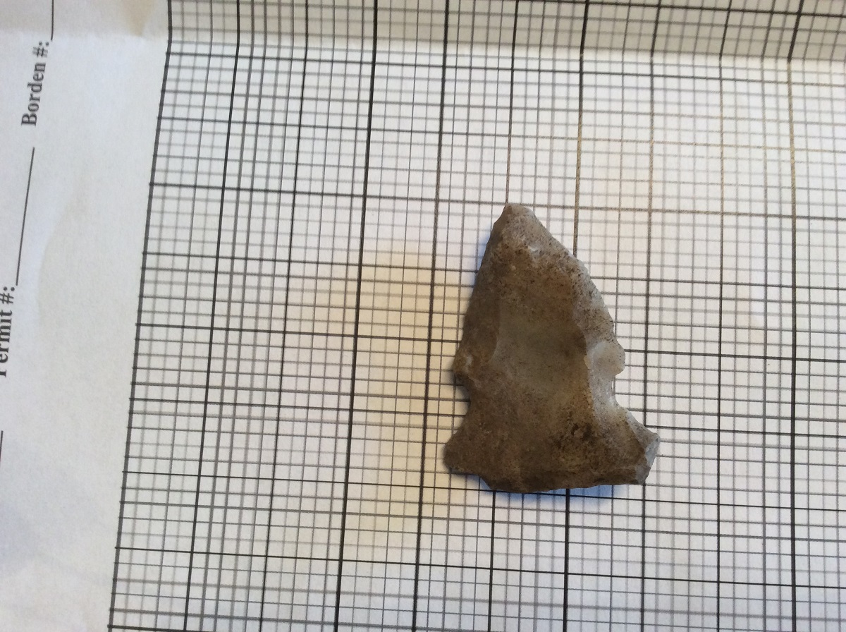
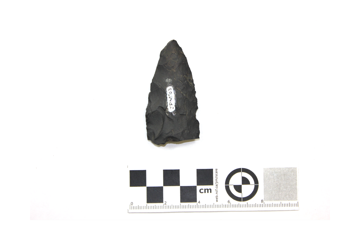
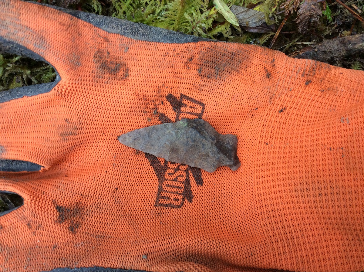
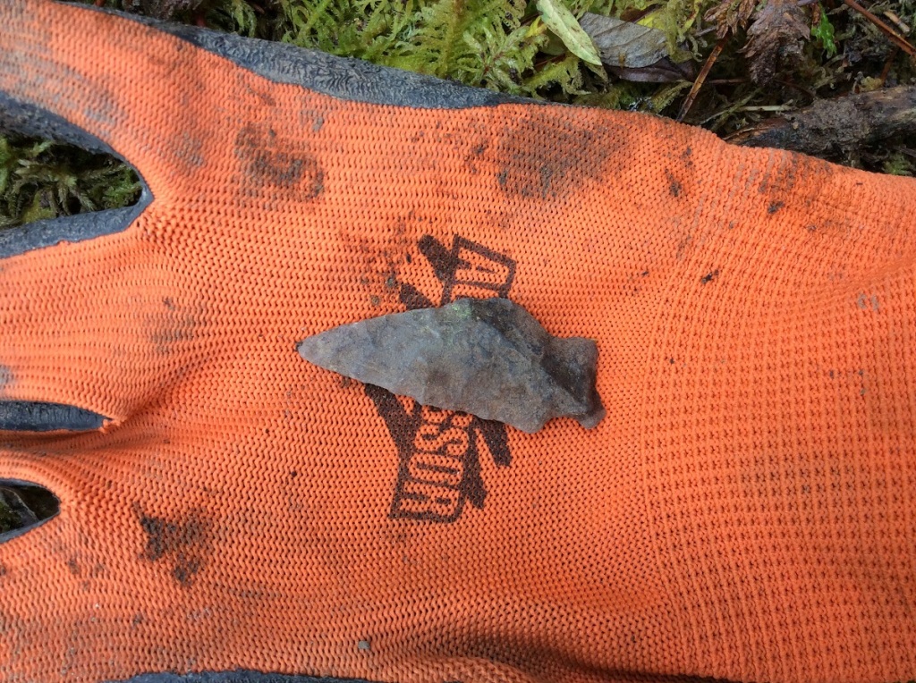
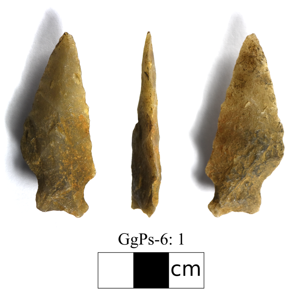
GgPs-6: Found while assessing a proposed cutblock for Vanderwell Contractors near Swan Hills, AB. The site is located on an irregular ridge surrounded by muskeg and set back from a small lake. At this site we found an asymmetrical projectile point made of quartzite. The projectile point doesn’t fit any of the established diagnostic styles known in Alberta, but could possibly be a hafted knife similar to this knife we found back in 2014.

FgPw-21: Found while assessing a proposed cutblock for Weyerhaeuser Pembina Timberlands near the Brazeau Reservoir. The site is located on prominent hill surrounded by muskeg. At this site we found a small biface made of purple quartzite and a utilized Knife River Flint flake. The biface appears to have been resharpened in the past and was likely once much larger. The tool was likely discarded once the flintknapper felt the tool became exhausted and unusable. The flake of Knife River Flint, is an exotic material that comes from a source in the Dakotas. Along the sharp edges of the flake, small chips we call utilization scars or wear was observed. Sometimes all a person needs is a sharp flake to get the job done!

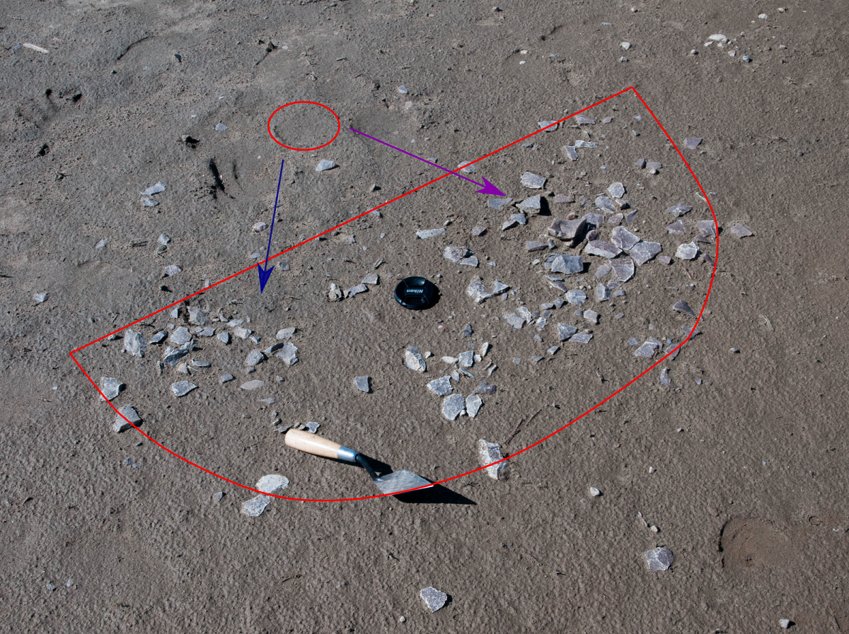
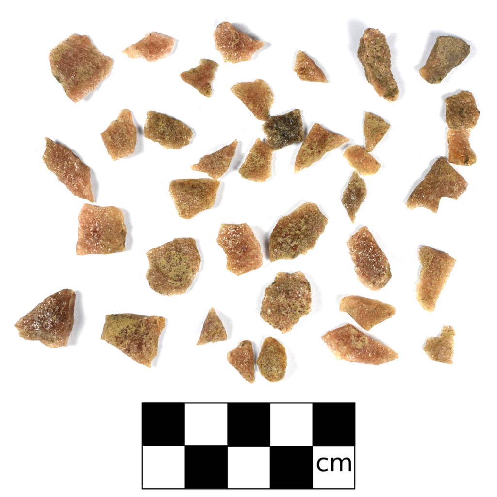
GgPs-10: Found while assessing a proposed cutblock for Vanderwell Contractors near Swan Hills, AB. The site is located on an irregular knoll overlooking muskeg to the south. Usually we find 1-10 flakes in shovel test, which we interpret as hitting the periphery of a flintknapping scatter likely associated with a single tool production event. Sometimes we get a positive test with 30-50 flakes in a shovel test and feel we hit the knapping area dead-on. If multiple lithic materials are present it likely represents various tool production events. But at this site we hit a full-on lithic workshop! We recovered four hammerstones, five cores, and a total of 7888 flakes!

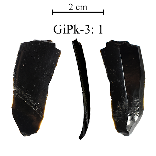
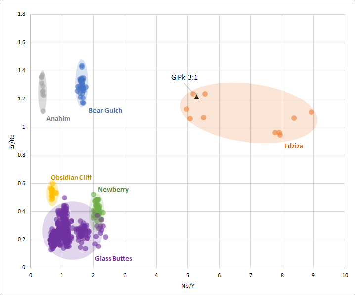
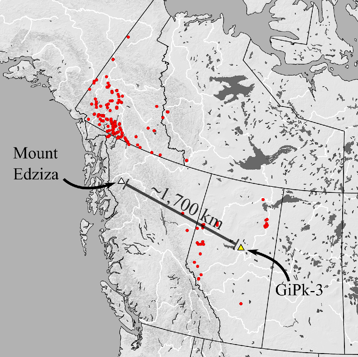
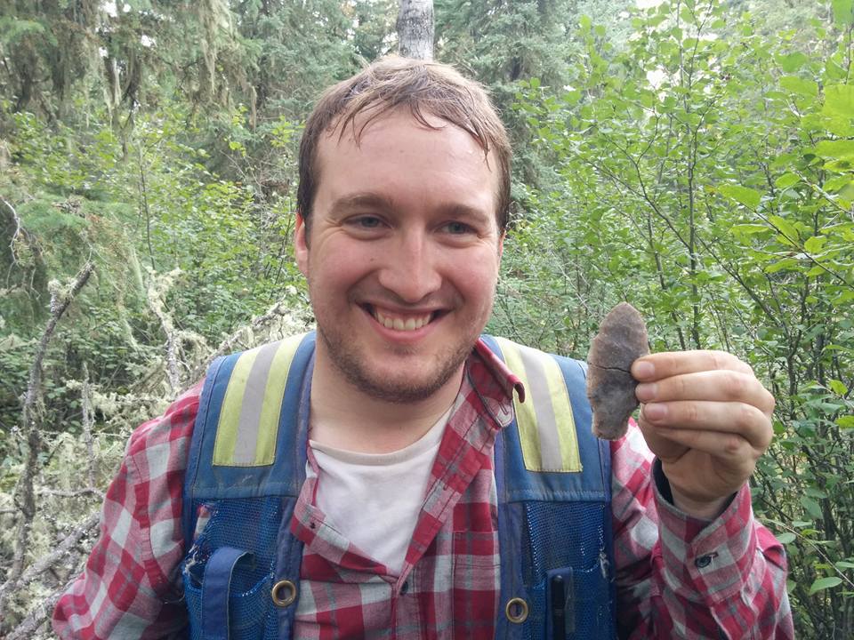
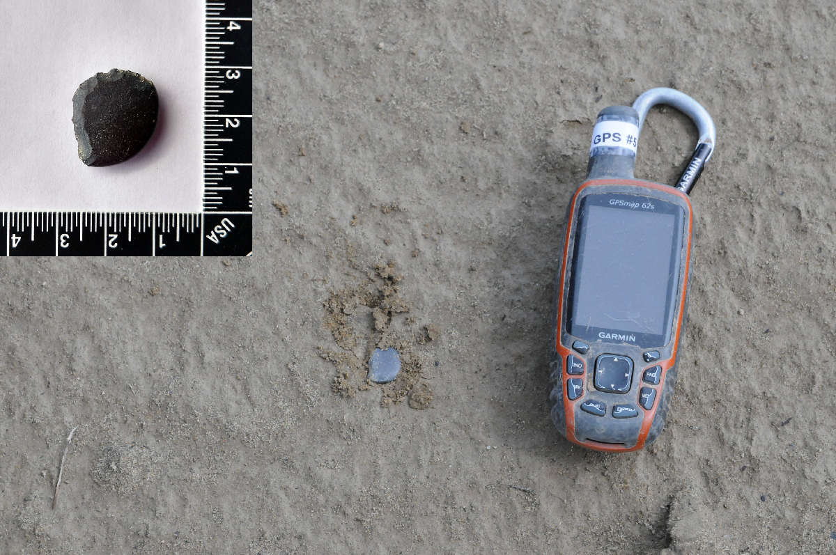
GiPk-3: Found while assessing a proposed cutblock for Vanderwell Contractors near the Fawcett River. The site is located on a small knoll located southwest of the river and overlooking a wetland to the south. Although we only found one artifact at this site, it is a very interesting tool. The tool is a portion of an obsidian flake made using microblade core technology. The blade has some utilization wear along the lateral edges, as indicated in the picture above. As we have discussed before, obsidian is a volcanic glass and each volcano has a unique chemical signature that allows us to trace where the artifact material came from. We were able to zap this specimen with the pXRF and discovered this obsidian came from over 1700 km from Mount Edziza in British Columbia!

FiPx-5: Found while assessing a proposed cutblock for Blue Ridge Lumber near Niton Junction, AB. The site is located on a long ridge that comes to a high point in the southeast. At this site we found a 90 m long site with flakes, cores, and one ugly projectile point. The projectile point might represent an aborted point that the flintknapper discarded. One of the lateral edges and the one of the notches are broken off, which may represent an error during tool production which resulted in the tool being discarded.

FiPx-2: Found while assessing a proposed cutblock for Blue Ridge Lumber near Niton Junction, AB. At this site we found lithic debitage, two cores and one bone awl. The bone awl is somewhat degraded and the point is not very sharp, but it appears to have been sharpened into a point at one end. The awl would have been used to pierce and mark materials such as leather and wood.

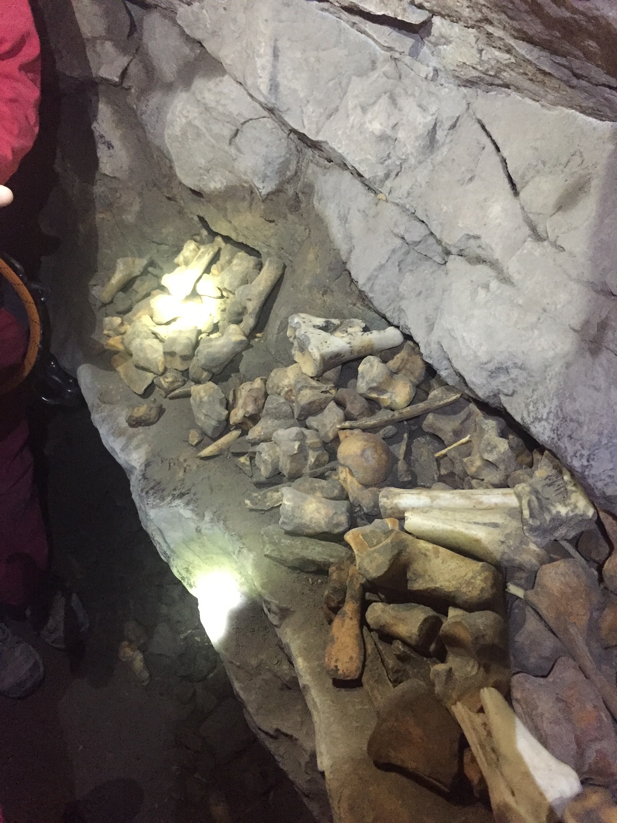
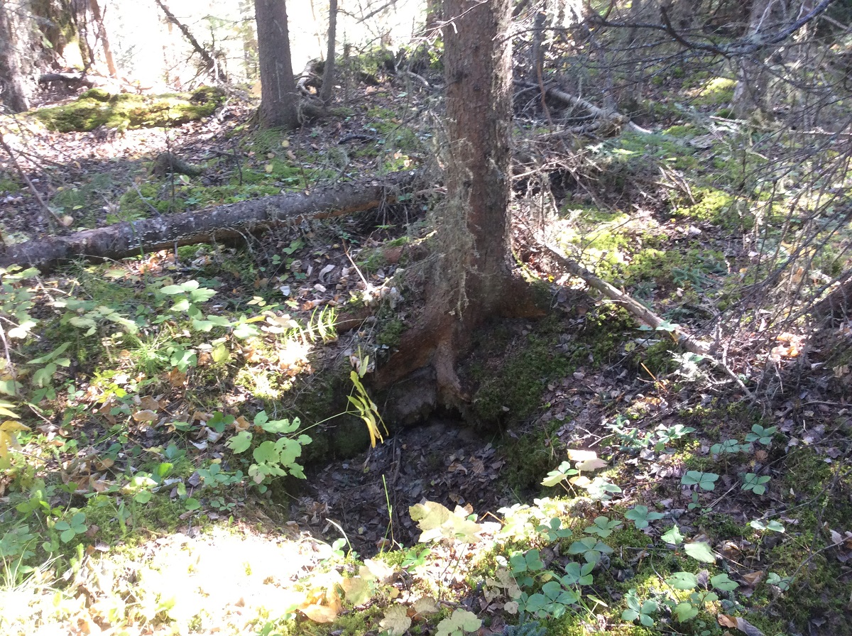
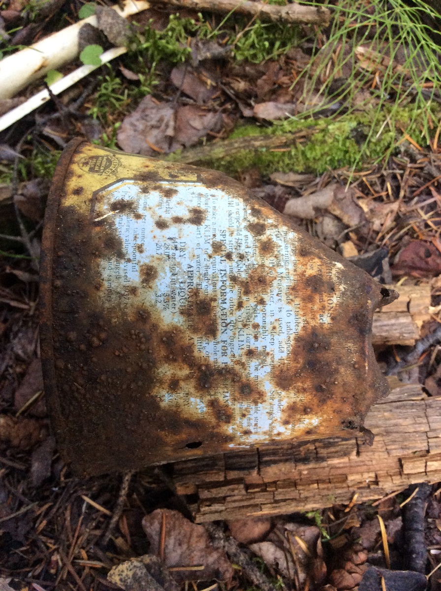
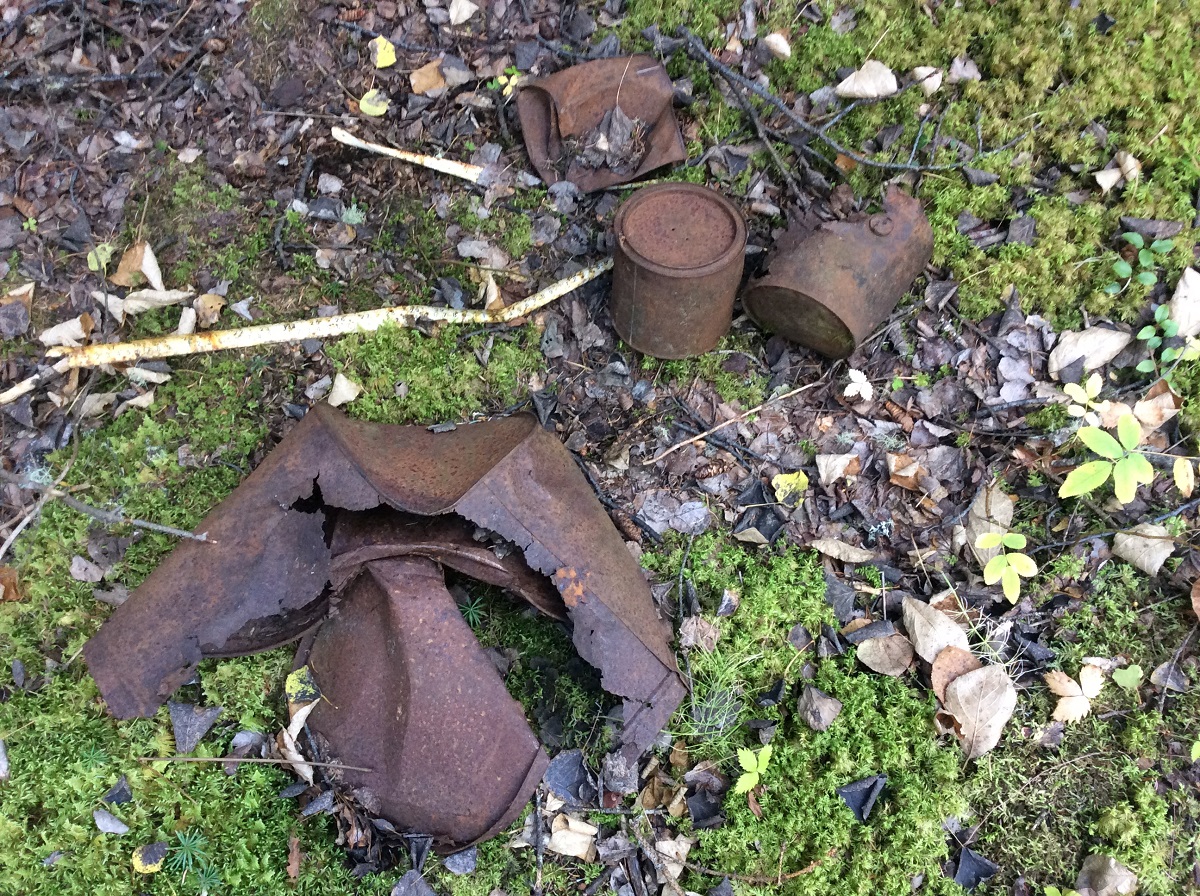
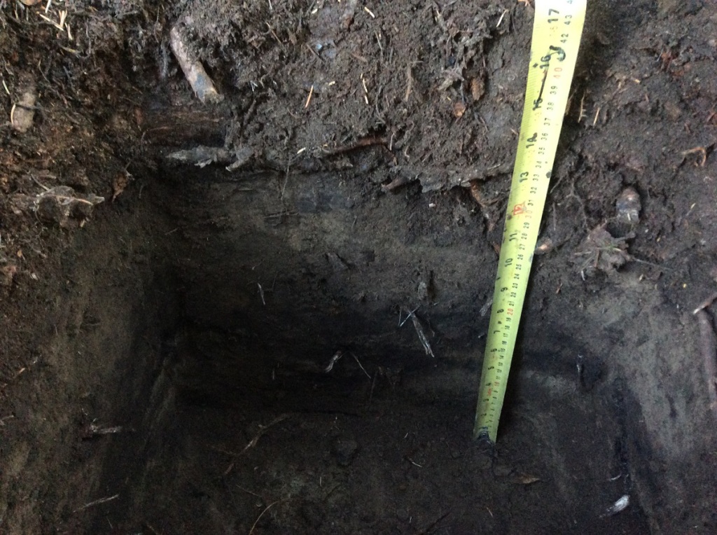
GdPu-19: Found while assessing a proposed cutblock for Blue Ridge Lumber near Swan Hills, AB. The site is located on a low southeast facing edge overlooking a relict oxbow. Although we didn’t find much lithic debitage at this site, we found two hearths (old campfires), 54 pieces of faunal remains (animal bones), and lots of charcoal. Two of the animal bones have indicators of human modification in the form of cutmarks, polish, and spiral fractures. The charcoal from both hearths and the calcined bone were all sent away for radiocarbon testing and received dates of: Charcoal Calibrated AD (1495-1650 AD); calcined bone Calibrated AD (1681-1937 AD). While not very old, this site is interesting in that it was occupied just prior to European Contact in Alberta!

FcPx-39: Found while assessing a proposed cutblock for Sundre Forest Products near Nordegg, AB. The site is located on a west-facing terrace overlooking Dutch Creek. At this site, we found a beautiful siltstone biface preform. Much like GiPk-3 and other sites where we only find one formed tool, these sites likely represent a tool being dropped or lost by hunter or flintknapper.

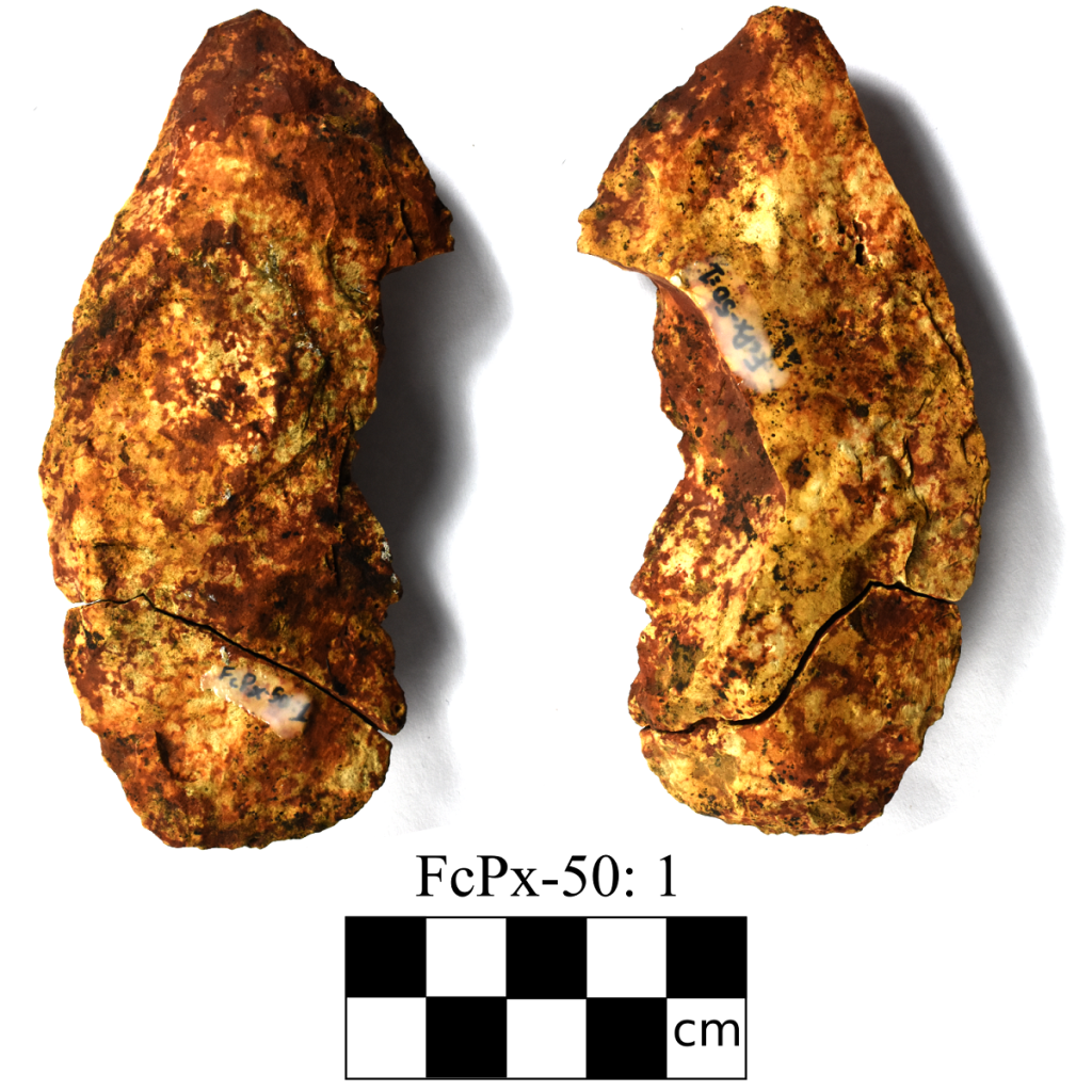
FcPx-50: Found while assessing a proposed cutblock for Sundre Forest Products near Nordegg, AB. This site is located on a series of rolling hills overlooking the North Saskatchewan River. At this site we found one biface and 15 pieces of lithic debitage. The biface is made from Red Deer Mudstone, also known as Paskapoo Chert, is a material we do not find often. Additionally, we also found one piece of obsidian which was sourced to Bear Gulch, Idaho.

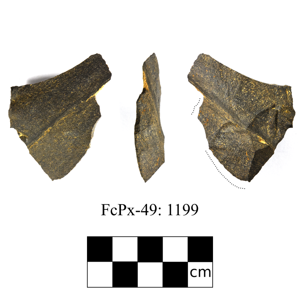
FcPx-49: Found while assessing a proposed cutblock for Sundre Forest Products near Nordegg, AB. This site is located on a large prominent ridge located back from a deeply-incised stream. At this site we had 12 positive tests over 170 x 75 m area. In these positive tests, we found one siltstone biface, two cores, one animal bone, and over 1000+ flakes. Several of the flakes also showed signs of utilization wear.

No volcanoes in Alberta, so where does the Obsidian come from?

When working close to an obsidian source (i.e. volcanoes), archaeologist will regularely find obsidian tools and debitage. However, in the boreal forests of northern Alberta, obsidian is a rare find indeed. So to find any evidence of it at all is pretty significant. Volcanic glass, or obsidian, is one of the sharpest naturally occurring materials on earth. It is sometimes used by surgeons who require a cutting edge that is much thinner and sharper than a stainless steel scalpel. Not only is obsidian extremely sharp, but it is also relatively easy to flint knap and is used by many beginners trying to learn this ancient skill. These features made obsidian a highly valued knapping material.

Pre-contact peoples fashioned various tool types from it, such as knives, projectile points, or composite tools. One method of knapping obsidian was blade core technology. This method involves preparing an obsidian core so that a series of small blades can be removed. This method minimizes the amount of material that is wasted and allowed people to quickly reproduce blades that were a similar size and shape. These blades were then hafted to a bone or stick to create a cutting utensil. To create larger tools, obsidian would have been knapped using normal methods as well.

Obsidian blade and core
Photo credit: B. Bernard

Last summer, Tim and I were surveying some forestry cutblocks at the base of the southern slopes of the Marten Hills, east Slave Lake. During the screening process, I had targeted a series of small knolls that overlooked a muskeg. These knolls were close to the headwaters of the Fawcett River, where a natural pass would have allowed people to easily traverse through the hills. Tim and I walked to the top of the highest knoll and started digging test pits.

Brian at GiPk-3 - Copy
Brian at the GiPk-3 hill top

We were completely shocked when my first test contained an obsidian blade. At this point we were extremely excited, and were sure that we had just found a crazy site. However, even though we dug 40+ test pits, we never found another artifact. The site turned out to be an isolated find. Nuts!

obsidian blade

So if there are no volcanoes in Alberta, where did this obsidian blade come from? Luckily, advances in technology allowed us to quickly solve this question. During his Master’s degree, Tim obtained a license to operate a pXFR analyzer (portable X-Ray Fluorescence), so Tree Time Services Inc. rented one of these devices. Other obsidian artifacts recovered by Tree Time services were all found to come from south of the U.S. border. However, the results of Tim’s analysis suggests that the blade was made of obsidian from Mt. Edziza, British Columbia.

pXRF
Results of pXRF, showing range for various volcanic sources.

That means that this piece of stone had been transported/traded by Pre-contact peoples over a distance of 1700 km! At 10 km travelling distance in a day (on foot), that is 170 days, or almost 6 months. Mt. Edziza obsidian has never been found in the Lesser Slave Lake region, however is is somewhat common in the Peace Region in northwest Alberta. GiPk-3 represents one of the furthest known Mt Edziza obsidian finds from its source. Although Tim and I were disappointed that we didn’t find more artifacts, this single find provided evidence for trade networks that spanned vast distances long before European contact.

Edziza to GiPk-3
Image Credit: Todd Kristensen

Rat’s Nest Cave – Pictographs

Last year I visited a very interesting site located near Canmore, AB. The Rat’s Nest Cave is accessible through the touring company, Canmore Cave Tours, and can be visited all year round. With the help of my guide, Brent, I rappelled 18 m into the cave and squeezed through many tight water carved gaps and tunnels. Eventually you reach “the grotto” where you can hang out by a crystal clear pool and several beautiful stalagmites and stalactites.

repelling
Left: Repelling into the cave.  Right: One of the many squeezes you will experience!

Also in the cave are many animal bones dating to approximately 7000 years ago and, although I didn’t see any while on the tour, several stone tools dating to 3000 years ago. One of the most fascinating aspects of the cave are the pictographs located at the entrance of the cave. Inside the cave, are several small rock paintings that indicate the cave was of cultural significance for the First Nations people possibly for thousands of years. My guide also informed me that there are several pictographs on the outside of the cave above the entrance but due to years of weathering they are not visible to the naked eye.

IMG_6045 - Copy
Assemblage of animal bones found in the cave

IMG_6033 - Copy
One of the rock art images inside the entrance to the cave

Luckily, recent advances in technology allow us to digitally enhance rock art paintings. A process called Decorrelation Stretch or simply D-Stretch is currently being used by archaeologists and rock art researchers to enhance even the faintest of pictographs. The process works by increasing differences in hue and stretching the contrast for each colour variance. When D-stretch is used to enhance the image of the entrance of the Rat’s Nest Cave, a series of handprints can be seen going up the wall.

wall above entrance
Left: Normal image of the wall above entrance.  Right: D-Stretch image of wall above entrance

eP4070027c - Copy
One of the handprints isolated (Photo Credit: Jack Brink)

Fort Edmonton Park Expansion

As part of the upcoming expansion of Fort Edmonton Park, an Indigenous Peoples Experience exhibit is being added. The multimedia exhibit will educate visitors about the Indigenous histories and cultures of the Edmonton region in an engaging and interactive way. The exhibit will include an outdoor amphitheatre, teepees, campsite recreations, and an indoor arena show.

FNE - Copy Sandra Green
Conceptual Design of Indigenous People’s Exhibit (subject to change). Photo Credit: Sandra Green.  Featured Image above – Bird’s Eye view of Indigenous People’s Exhibit (subject to change. Photo Credit : Brittany Cherweniuk.

For the purposes of authenticity, the park contracted Corey and Brittany, with another independent contractor, Alexandra Burchill, to do historical research on the Edmonton region during the period of 1600-1850 AD. Their research will be used to inform the exhibit content and educate the interpretive staff. The team analyzed several different source materials including: primary sources, secondary sources, archaeological reports, archival records, and recorded oral histories.

fort_ed_presentation - Copy
The Research Team presenting at Fort Edmonton

The team also took part in a training program for the interpretative staff. Corey, Brittany, and Alex spent two evenings with the Fort Edmonton Park interpreters presenting their research. They also had several artifact reproductions for the staff to touch and ask questions about. Several staff took the opportunity to try ancient tool technologies such as the bow drill and atlatl throwing.

IMG_20170727_181734 - Copy
Corey demonstrating tool use for the Fort Edmonton Interpretive Staff

As part of the research process, Treaty Six Elders were consulted and collaborated with to ensure the accuracy of research and identify areas that conflict with Indigenous knowledge, oral traditions, and culturally sensitive topics. Several stories told to us by the Elders were incorporated into the synthesis report including a story of an Elder that remembered his mother using a sharp obsidian flake to make small incisions on his temples to relieve headaches. We found this story to be an interesting addition to our discussion of the persistence of stone tool technologies after the introduction of European goods.

treaty Lodge - Copy Brittany Cherweniuk
Conceptual image of the Treaty Lodge (subject to change). Photo credit: Brittany Cherweniuk.

The project was a very educational experience for the research team learning a lot about the history of the Edmonton river valley. But more importantly, the project brought us together with many different people, all united by a love of history and respect for the Indigenous past of the place we all call home.

The Alook Site – HaPl-1

Although the Wabasca-Desmarais regions is rich in cultural heritage, very few in-depth archaeological investigations have been conducted. HaPl-1, also known as the Alook site, is one of the few sites in the region that has actually been excavated or received any interest past its initial identification. In the 1960s and again in the 1070s, a team from the University of Alberta did preliminary excavations at the site. The results speak of a very long history!

Wabasca map - Copy
Archaeological sites around Wabasca-Desmarais

The Alook Site was found on a small knoll along the north shore of the North Wabasca Lake. The site is named after John Alook, a band council member who lived in the area. In the early years of archaeology in Alberta sites were often named after the landowner or the person who reported the site, although it is unclear if John Alook was one of these people or named in his honour. Test excavations were conducted by the University of Alberta in 1969, but the band did not receive a report of the initial findings until 1977. Later that summer additional excavations were conducted under the direction of Cort Sims.

Excavations at the Alook Site included three 1×2 meter test trenches excavated in 1969, and a 4×8 meter excavation trench that was placed directly east of these in 1977. These trenches focused on the undisturbed western part of the knoll, as the eastern part was a little disturbed by a garden, and the reported possible location of the original house. The 1969 excavations recovered a total of 891 artifacts. The types of artifacts found suggested that HaPl-1 was an indigenous campsite that had seen substantial use. The artifact types included projectile points, biface fragments, scrapers, and an assortment of lithic debitage. One of the most significant finds was a McKean projectile point, found in the garden. The McKean point suggested that the site dates to the Middle Prehistoric period, or approximately 4200 to 3000 years before present.

mckean_record in stone
Examples of McKean projectile points from Alberta (modified from “Record in Stone”, Archaeological Society of Alberta, 2012).

The 1977 excavations helped us understand more of the site and its use by past peoples. A total of 131 stone tools and tool fragments were recovered. The recovered artifacts reinforced the initial suggestion that HaPl-1 is a campsite that had seen significant use. Seventeen projectile points and 11 projectile point fragments were found at the site. Points are also considered “diagnostic” artifacts, because variations in style can reflect change over time, or points made by different cultural groups. Some of the projectile points were also of the Plains arrowhead type, which generally date from 1100 to 250 years before present. These can tell us what kinds of hunting activities were being done in the area. That fact that both McKean and Plains projectile points were recovered is significant, as it shows this site was occupied at multiple times throughout the past.

Almost 40 scrapers were found, which tell us that hide processing was likely a major activity at the site. The other tool types found include utilized flakes, hammer stones, anvils, an adze and adze fragment, core fragments, bifaces, and worked pebbles. The number and variety of tools found at the site were what led researchers to suggest that this site was a major campsite, since these artifacts suggests that a multitude of different activities occurred at this location. These tools probably reflect activities as diverse as making stone tools, drying meat or fish, and wood-working. These activities are all consistent with traditional life at a major lakeshore campsite or summer settlement.

Alook artifacts - Copy
Some of the artifacts from the Alook Site.  Artifacts B and D are examples of side-notched points, estimated to be 1100 to 250 years old.  Artifact C is possibly a Beasant point that dates from 2500 to 1350 years old (modified from “Archaeological investigations in the North Wabasca Lake area: The Alook Site”, by C. Sims. 

During the 1977 excavations a midden feature, or refuse pile, was also uncovered. Since one of the goals of the work that year was to recover some organic material for radiocarbon dating, this was a substantial find. Radio carbon dating provided an age of 2165 to 1815 years before present, which places the site within the Besant phase. This date, combined with the McKean and side-notched projectile points found, show that this site was likely in use from at least 4000 years ago to the present. To put this in perspective, HaPl-1 was likely occupied long before the Roman Empire came into existence and is still in use today, as at present the site contains a modern house. Talk about continuity!

Although a substantial amount of information was learned from the excavations at HaPl-1, there is still much more work needed to gain a better understanding of the past life-ways of people in the Wabasca-Desmarais region. Cultural heritage is important for bringing people together and creating a dialogue of openness and acceptance in the region. First Nations people have inhabited the region surrounding the modern town of Wabasca-Desmarais for more than 4000 years (and more likely 10 000 years). This is an aspect of our heritage and history shared by all Albertans. Stories like this are a part of all of our heritage we are all treaty peoples and share a collective history.

Cabin in the Woods

One day last fall, Vince and I went to revisit an old cabin that had been found deep in the Swan Hills. This cabin had been found during an historic resource impact assessment back in 2009, and we just need to check to make sure that the new harvest block was going to avoid the site. The cabin, GfQa-2, was located on the tip of a narrow point along the East Prairie River valley, approximately 60 km south of Driftpile, Alberta.

IMG_20170930_135614 - Copy
Looking out over the Swan Hills

After a long hike through dense fir, we finally reached the recorded spot for the cabin. Unfortunately, there wasn’t much of a structure to see on the surface. It took us a few minutes to find the 5 by 5 meter square outline of the cabin foundations, right on the river valley edge. It was hard to see as there was only one course of saw-cut logs remaining from the walls and even these were covered in a thick layer of moss and lichen. The cabin had been collapsed for so long that even a large white spruce tree was growing over one of the corners.

cabin remains - Copy.jpg
Remnants of the cabin walls at GfQa-2, with a white spruce tree growing over the corner

logs - Copy
Hand-cut logs used in the construction of the cabin

We also noticed two small pits near the cabin walls. The smaller of the two pit features (roughly 1 m in diameter and 60 cm deep) was about 15 meters southeast of the cabin. The second larger pit (2 by 1 m and 60 cm deep) was location a few meters northeast of the cabin wall. We couldn’t find any artifacts in these pits, but we concluded that the smaller pit was likely the privy and that the bigger one may have been some type of root cellar.

IMG_1617 - Copy
The smaller pit, right up against a small white spruce tree

In contrast to the cabin itself, it was much easier to find the piles of historic artifact around the cabin entrance. Lying on the mossy surface of the site were a number of a metal buckets, glass mason jars, and several rusted metal cans. Artifacts like these are fairly common at historic cabin sites, and at first glance, these artifacts might seem like rusted bits of garbage. However, Vince and I were actually able to find out a lot about the site by looking at these artifacts. For example, one of these cans found a second life as a strainer. The label had long since rusted off of this can so we can’t tell what it originally held, but the bottom of the can had been repeatedly punched with a square nail or metal punch. I suspect that the people living at the cabin weren’t cooking up pasta, instead this can may have been used to wash berries or any number of small food items.

IMG_1609 - Copy.JPG
Can with perforated bottom at GfQa-2

The three artifacts that revealed the most about the people who lived at the site were a set of cans with the labels still preserved. With these labels, we can identify what kinds of food products were brought to the site, and the time period when they were purchased. Certain important changes to labeling laws, like the introduction of the metric system in 1976, can help us to determine age brackets for an artifact (Must be younger or older than X date). Certain styles of labels can also help us to isolate a time period (like a ‘Phantom Menace’ commemorative Pepsi Can that could only date to 1999). By comparing the artifacts to preserved examples of different branded products, we can begin to isolate when this historic cabin was occupied. Unfortunately, the labeling style of different brands that were used in the past has not been well documented, so it is difficult to precisely date a can, even when there is a label.

sugar can - Copy
On the left a can from GfQa-2, on the right a can of Roger’s Golden Syrup from the BC Sugary Refinery (Kneehill Museum, Three Hills AB).  The details on the building are slightly different, but the company name is still largely preserved along with the red strip around the top.

The first can we identified was a 20 lb can of Roger’s Golden Syrup from the BC Sugary Refinery. This company began the production a variety of sugar-based products in 1891 and we still buy Roger’s Sugar products today in our grocery stores. There is no date listed on the can but the style of the label seems to match examples of preserved cans from the 1940’s and 50’s.

klim - Copy
On the left an artifact from GfQa-2, on the right a preserved Borden Company Klim can. Note the similar type font and printing at the bottom and the similar corners on the label background. One difference is that the preserved label was green as opposed to brown, but it might just represent a different manufacturing period or that the colour has faded from brown to green over time.

The second can that we were able to identify was a tin of Klim from the Borden Company. Klim is a brand of powdered or condensed milk, that was extremely popular throughout the 1900’s. Originally produced by the Merrell-Soule Company in New York, Klim was marketed with the slogan, “Spell it Backwards’. In 1927, the brand was purchased by the Borden Company and remarketed as a Borden Company product. We can only see part of the label on the artifact preserved at the cabin, but the type font and labeling matches other examples of Borden Company Brand Klim. The Klim brand now belongs to Nestle, who continue to produce Klim powdered milk products around the world.

IMG_1603 - Copy
Unidentifiable can

The third can was the most difficult to identify, as most of the label has been covered with rust and the company name was not preserved. It does seems, however, that this is another can of Borden Company Klim. This is largely based on the shape of the label border and the colour of the can, which is similar to the front of the other preserved label. There was a fair bit of interesting material to read on this label. There is a seal of approval from the American Medical Association (bottom left of label). In 1929, the American Medical Association started a committee to approve the quality and safety of infant formula and other food products. Similarly, one portion of the label reports that the product adheres to the 1937 standards for caloric values. Throughout the 1930’s in Canada and the United States, there was a large push to create a framework for people to maintain optimal health, as well as to combat false or inaccurate claims for food products. The instructions printed on the can also list how to best mix the Klim with water or coffee, as well as a set of special information for physicians to make the equivalent of whole milk. So based on this, it seems likely that this was a can of Klim, produced some time after 1937.

Looking around at the other type of cans we found at the site, a number of them have a similar size and design to the Rogers Golden Syrup container, as well tins of Klim. It seems then that the owner of the cabin had a bit of sweet tooth when it came to their meals. Another intriguing possibility is that the Klim and syrup were used for baby formula, as these are common ingredients in early 20th century baby formulas. During the 1930’s through 1960’s, it was common for mothers to mix powdered milk with honey or syrup to used as infant formula. This was a practice that was recommended by many doctors at the time as the mixture was fattening, even though earlier condense milk products during this period lacked any significant amount of nutrients or minerals (These were added later once doctors realized that we need them to survive). So we might be seeing evidence that a family was living at this cabin, but it is hard to say conclusively that this was the case.

IMG_1593 - Copy
Examples of other cans found at the site. Most are similar in size to the syrup and Klim cans. We also found a broken tape measure from the archaeologists who found the site, circa 2009!

Based on the kinds of artifacts we were able to identified, we can reasonably guess that the cabin was built some time after 1937 and probably used during the 1940’s or 50’s. But how long did people continue to live at the cabin? The structure is largely gone, so we know that it has been left for some time. However, it is hard to know how long a place has been abandoned. Historic structures can often go through different phases of use, from a permanent residence to a seasonal home or travelers rest stop. One way to determine this is to look at the local vegetation and see how much has grown over the site. At this site, there is a dense growth of balsam fir and white spruce over the site, so it appears to be abandoned for some time. There was also one particularly large white spruce with a diameter of about 30 cm, growing over the south corner of the cabin. This is the perfect situation to determine the amount of time since the cabin was abandoned, because that tree could only start growing after the roof and walls of the cabin had collapsed. Tree growth rates vary considerably based on local conditions, but it would likely take approximately 40 to 60 years for a white spruce to reach that diameter and height. So, given what we know from the artifacts at the site, we can conclude then that this cabin was occupied some time between 1937 and abandoned some time after the 1960’s.
From a few cans in the middle of the forest, deep in the Swan Hills, we can get a snap shot of life from almost 70 years ago. We can see the kind of food that people were eating and what they considered important enough to carry 60 kilometers into the bush with them. Even though this little neck of the woods might seem secluded, so remote that you’d think nobody would visit, but just over 2 kilometers away from this cabin, on a little ridge, we found a 10,000 year old spear point. From the Ice Age to the Modern Age, it goes to show how even the most remote places can have the deepest history.

Reid with Point - Copy

Authors Note: If you feel like you can better identify these cans, or if you feel like you know who could have lived at this cabin, please feel free to leave a comment or contact us directly about it. Any information that you share will be greatly appreciate and will also help us to tell the stories of the areas we visit.

Tree Time’s 2017 Top Five Sites

Now that all the reporting is done, we thought it was a good time to look back on some of the exciting sites we worked on from the past year. We usually find over 100 sites every year but these sites stand out either because we found interesting artifacts or the site is unique compared to the sites we generally find. It doesn’t matter how many points an archaeologist has found throughout their career, they will still get really excited when they pull a projectile point out of the their screen! In fact, compiling this list got me really excited to get out of the office and back into the field where an archaeologist belongs.

alberta_top_5 - Copy

ElPs-56: Found while assessing a proposed cutblock for Sundre Forest Products near the South James River. It’s located on a distinct corner, so we couldn’t miss the landform. What makes this site exciting is that Brian found a Beasant point! We don’t often find these during a shovel test program (compared to excavations). It was likely dropped there by a past hunter while looking out over the valley below. We also found several flakes and a hammerstone which suggests people were also making tools at this location.

FePr-4: Found while assessing a proposed cutblock for Weyerhaeuser Pembina Timberlands. The site was located on terrace edge overlooking an old oxbow of Wolf Creek. The site has a very diverse artifact assemblage consisting of various materials including mudstone, petrified wood, chalcedony, and quartzite. The most interesting find was a piece of obsidian. Obsidian is volcanic glass and only comes from areas with volcanic activity. The presence of obsidian suggests either long distance trade outside of Alberta, or long distance movement of people.

GfQa-5: Found while assessing a proposed cutblock for North Central Woodlands. At this site we found a salt-and-pepper quartzite spear point preform on a small ridge in the Swan Hills. The point likely broke in half during the manufacture of the tool. The site is interesting because spear points such as Alberta or Hellgap points (which are similar to this point stylistically) are typically dated to approximately 10,000 to 8,000 years ago. Also recovered at the site were the molars of an adult moose but unfortunately in a different context than the point. Further testing at the site may recovered datable materials that can be associated with the point.

GiPl-13: This site was found near Howard and Fawcett Lake by the layout crew of Tolko Slave Lake Industries. We visited the site to document and confirm what type of site the flagging crew found. Upon visiting the site we found six collapsed structures, five mounded rectangles, and lots of mechanical and other types of debris. Our initial interpretation was that the site was an old forestry camp. Further background research revealed that area was known to have a WWII prisoner of war camp, where POWs often worked for the forestry sector. It’s possible this camp may have been related to the work they did. We analyzed the artifacts identified at the site and found one of the pieces of ceramic had a makers mark that read “Medalta Made In Canada.” This ceramic seal dates to between 1937 and 1943. Further research is needed at the site to confirm it is a POW camp from WWII. If it is, the site is very significant for learning how POW’s were treated, lived, and contributed to industry during WWII.

KkDo-1: Kurtis and Vince spent a week excavating a sod house on a remote part of Baffin Island in the Qaummaarviit Territorial Park last October. This was a unique opportunity for us because we typically only work in Alberta. However, Vince’s experience from his graduate research on a historic Inuit house in Newfoundland made him well suited to the project. While excavating the house they found spears, harpoons, and projectile points while working along side the local descendant community. In fact, one of the Inuit team members, Naulaq Inookie, is a direct descendant of the people who lived there. The sod house dates to between 1200-1800 AD and will be eventually reconstructed as a tourist attraction.

DSC03064 - Copy
Setting up the excavation units at the Sod House

DSC03090 - Copy
View of the camp at night!

Publicly Reported Sites

In 2016 two members of the public contacted Tree Time Services to report archaeological sites that they had discovered. Our Archaeological Roadshow was being hosted by the Sundre Museum, during which we were approached by the first person who had found a side-notched projectile point while planting her garden. We arranged to meet her at her home to record the site. We took photos of her garden and recorded the location using a hand-held GPS unit of where she recalled finding the projectile point. We also took photos of the projectile point itself. Our time with her allowed us to collect the data we needed to report the site as EkPp-18. While the site is highly disturbed due to the construction of the subdivision it is still important to record the location of her site and what was found. This information will help future archaeologists to predict where other similar sites in the area can be found.

IMG_0851 - Copy
Side-notched point found in the garden.

The second community member to contact us got in touch with Kurtis to let him know about six sites he found while hiking and hunting in the region. Teresa and I took a day off from working for our client to spend with him visiting the sites he had found. While we were there, we recorded the locations of where he had found artifacts, took photos and conducted surface inspections resulting in the identification of additional artifacts. The artifact collection is being catalogued by Tree Time so that we can record data to the standards required by the Royal Alberta Museum. This way we can submit site forms to the government of Alberta, just as we did for the previous person’s site. These site forms will have a detailed description of the archaeological sites found and a full listing of the number and types of artifacts found at each site. A copy of these catalogues will be sent to the Royal Alberta Museum when we have completed the reporting process. The museum needs a copy of the catalogue so that if any future work is completed at these sites they will be able to provide the researchers with a starting catalogue number, avoiding duplicates in the database. This way it is easy for researchers to know how many and what kinds of artifacts have come from a particular site, even if the museum doesn’t have the artifacts themselves.

image4163
Bifacial fragment found while hiking.

We are always happy when people are willing to share their archaeological finds with us because the government cannot protect sites they don’t know exist. Researchers also need this information to build predictive models and to choose what areas would be interesting to conduct more research at.

If you have found an archaeological site and would like help to record it please contact Kurtis at 780-472-8878 or email archaeology@treetime.ca.

Context

The context of an artifact is extremely important to archaeologists. The context of an artifact means the precise location of the artifact and it’s association with other artifacts and landscape features. This helps us determine such things as the relationships between artifacts on a site, it’s position in time and space, and even how it is related to different archaeological sites.

Below is a picture from a site near the Brazeau Reservoir, Alberta. The lithic scatter pictured below shows the flakes in their original context. The whole scatter is in a semi circle shape outlined in red. The positions of the flakes indicate that someone likely sat near the red circle. They then flint knapped purple quartzite which went in the direction of the purple arrow. They then shifted their body and began to flint knap a grey-blue quartzite that went in the direction of the blue arrow.

This is just a small portion of the site, so when we start to put together this information with other information about the site we begin to get a greater understanding of what happened, such as where specific activities took place and even what was going on in the area at that time.

Public Archaeology at the Brazeau Reservoir

Public archaeological programs are an excellent opportunity for people with a general interest in archaeology or amateur archaeologists to learn what an artifact is, and to practice the techniques that are used to find and interpret them. Often these programs will have a dig component, where people join for a few days or a week, and learn excavation techniques in units laid out over a buried site.

The Brazeau Archaeological Project (BAP), sponsored in part by Tree Time Services Inc., provides a unique experience. The current sites being surveyed are almost entirely exposed by the continuously fluctuating water levels of the reservoir. This also means that the entire history of the area has been deflated to one level, rather than multiple occupation levels that can be apparent in excavations. The occupation of the Brazeau River by First Nations extends as far back as 12- 14,000 years ago. This allows participants to gain a better feel of how large and spread out an archaeological site can really be. The largest site surveyed so far spans almost 1 km!

DSC00028_jack brink - Copy
Bob Dawe (left) discussing boiling pits. Photo Credit: Jack Brink

The project invites members of the Strathcona Archaeological Society (SAS) to come out for a day or weekend to learn survey and excavation techniques, as directed by experienced or professional archaeologists. As most of the artifacts lay exposed on the surface due to the ever changing water levels of the reservoir, the experience is relaxed, family friendly, and can be conducted over a single day or weekend, rather than a week-long commitment.

participants_hilary mcdonalnd and madeline - Copy
Participants surveying, excavating, and generally having a good time!  Photo credit: Top and left – Hilary McDonald; right – Madeline Coleman

Participants learn what features to look for when looking for surface finds, such as material, shape, and modifications. By pairing participants up with experienced archaeologists we can point out the various ways an artifact, such a flake, can look; particularly how it can blend in or really stand out from its surrounding environment. For example, Amandah van Merlin, one of the co-ordinators, picked up a small, indistinct black pebble. The black pebble chert material, however, is a popular flint knapping material. As it turned out, Amandah had found a thumbnail scraper!

thumbnail - Copy
A small pebble with a big surprise!  Photo credit: Amandah van Merlin; inset – Madeline Coleman

Public archaeology programs are also a great way to explore new technology or try experiments. One participant brought his drone. He was able to take photos from a bird’s-eye view of the site, providing a totally new perspective on what these landforms look like along the shore, and the distances between the sites. Madeline Coleman, the other co-ordinator, laid out various sizes of brick pieces in order to examine how artifacts are affected by water movement (or perhaps even people).

ariel view - Copy
Ariel view of FfPv-1.  Photo credit: Robert Wambold

experiment - Copy
Laying out pieces of brick to monitor movement over time.  Photo credit: Madeline Coleman

The project is still in its infancy. The pilot survey in May 2015 occurred over one day and had 9 participants. In May 2016, the survey occurred over two days with over thirty participants joining for one or both days. This past May, there were over 20 participants that joined for the full weekend. In addition, for two days prior to the public survey, BAP worked with University of Alberta field school students. Here they practiced map making, shovel testing, and laying out excavation units.

Outreach is also a very important aspect of a public program, such to First Nations group, schools, and universities. The BAP has recently reached out to Paul First Nation, in whose traditional territory the Brazeau River lies, and whom are active in working to protect their heritage. BAP has also recently partnered with Katie Biittner at Grant MacEwan University to begin a hands-on catalogue experience for university students at Grant MacEwan and the University of Alberta. In addition, the original finders of the site, Sandy and Tom Erikson, worked to create a 3-case display at their hometown school in Edson. The case shows some of the finds and information from the periods they may have originated in.

edson display
School display in Edson. Photo credit Sandy Erikson