What a Sweet Spot!

Photo by Uriel Mont on Pexels.com

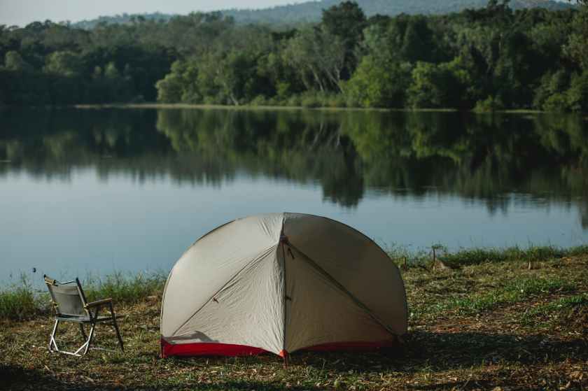
Have you ever been outside enjoying nature and thought to yourself – this sure is a sweet spot! Whether you are camping, fishing, hunting, or just enjoying the outdoors, there are certain aspects of our favorite spots that make them ideal and cherished. Nice sheltered level ground near the river – great for camping and fishing. Elevated location with a 270° degree view overlooking a muskeg – great for moose hunting. It just so happens that many of the things we look for in the perfect camping or hunting spot, are also the characteristics that First Nations people were looking for throughout the many millennia that they inhabited North America.

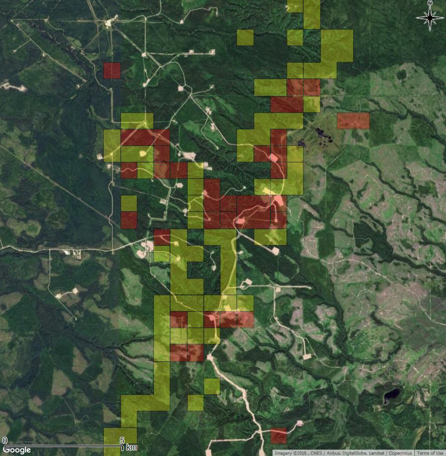
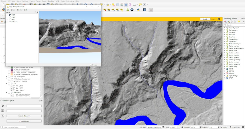
Archaeologists at Tree Time Services Inc. use high-resolution imagery, 3D and predictive modelling , as well as keen eye, when screening development footprints for our clients. However much of what we do boils down to simply trying to find good camping and resource procurement areas within the footprint. When our survey crews walk up to a targeted landform and see an ideal camp site or vantage point, usually someone will confidently declare that this is a site, or comment that ‘this is a sweet spot!’ – more often than not, they’re right!

High resolution LIDAR and 3D models of landscape aid in archaeological site detection.

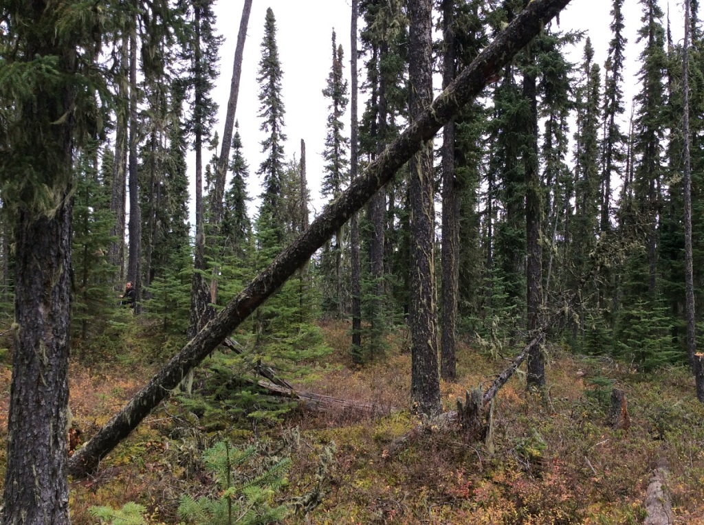
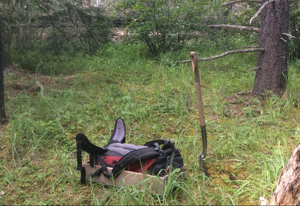
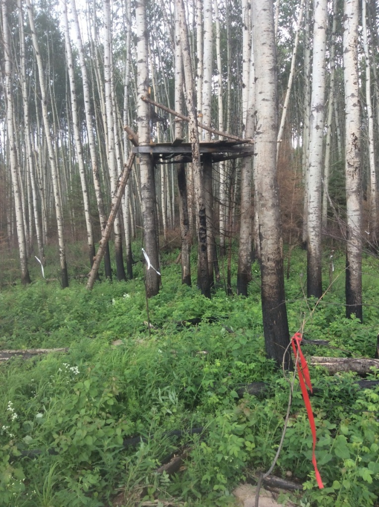
In 2016, Kurt and I were doing some work for Alberta-Pacific Forest Industries in an area near Anzac that was affected by the Ft. McMurray wildfire. During screening, Corey had targeted a small knoll along a continuous bench with low-lying, marshy terrain to the south. Upon arriving at this location, both Kurt and I took note of the panoramic view that this little knoll offered, and it just so happens that someone else had as well. A permanent hunting stand had been erected on the knoll. Although it looked slightly aged, it was still strong and sturdy.

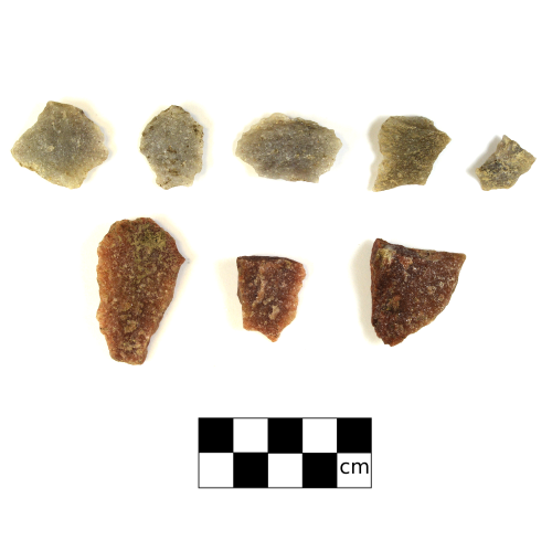
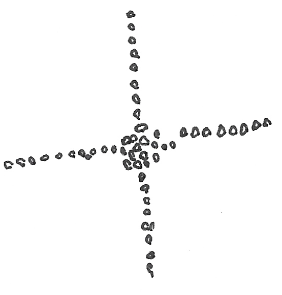
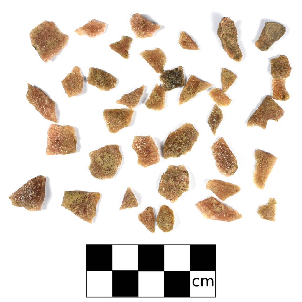
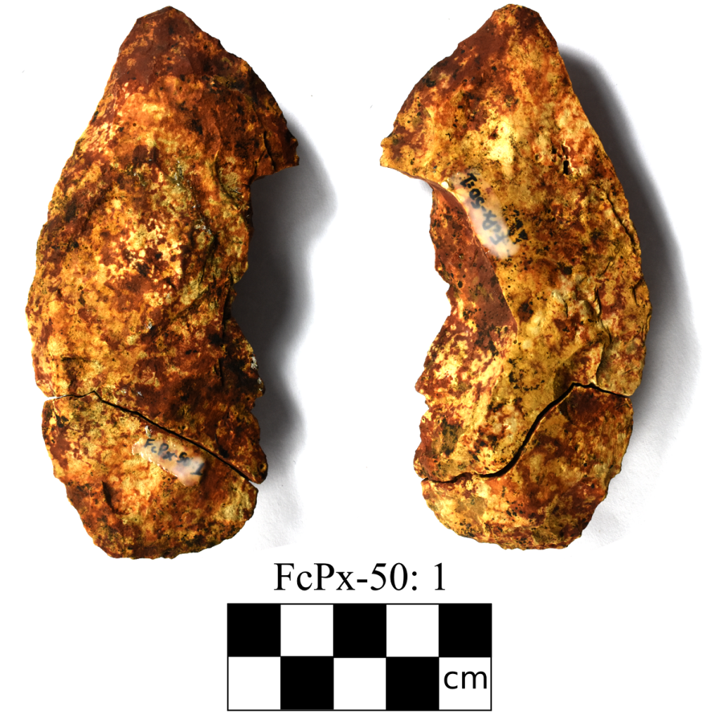
After only a couple quick shovel tests, Kurt found a single chert flake and we were able to designate the knoll as a new archaeological site. We then delineated the site (determined how big it is), but after many more tests, we had failed to recover another artifact. Somewhat disheartened that this site would only be recorded as a small, isolated find, Kurt started flagging the buffer and suggested that I continue digging some evaluative shovel tests. Digging these extra shovel tests may recover more artifacts, and add to our gathered information. I dug a couple more tests close to where Kurt found the flake with no luck.

Modern tree stand behind a positive test pit.

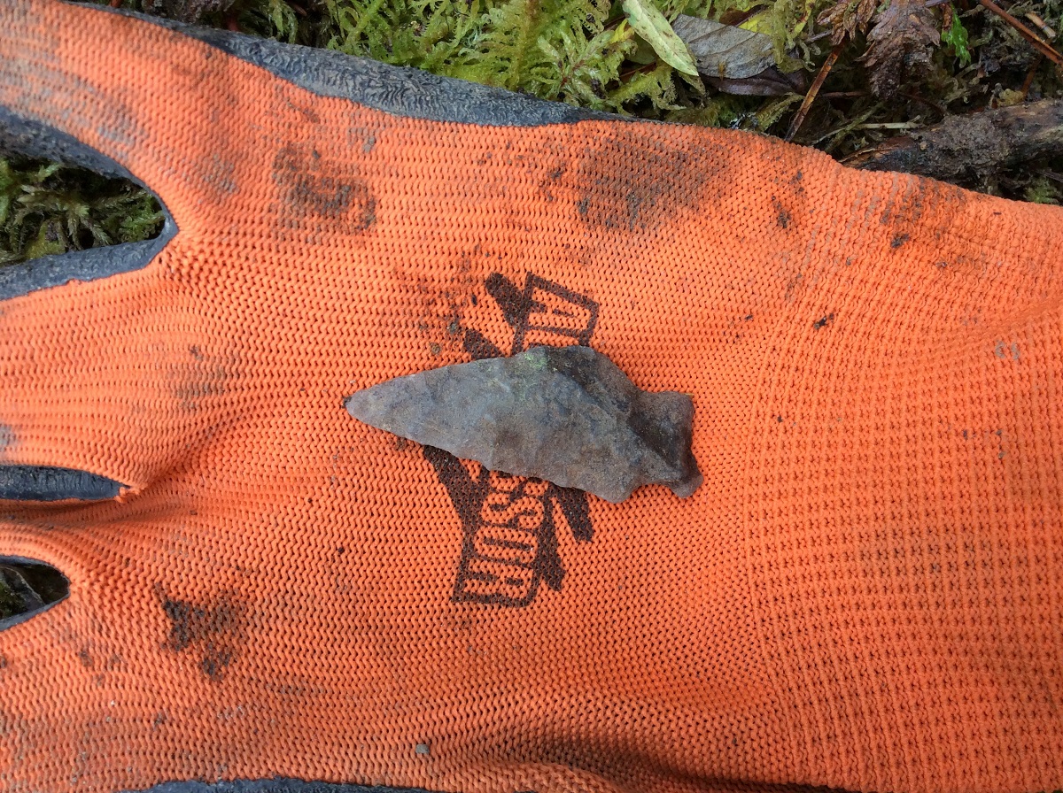
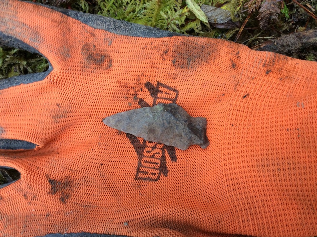
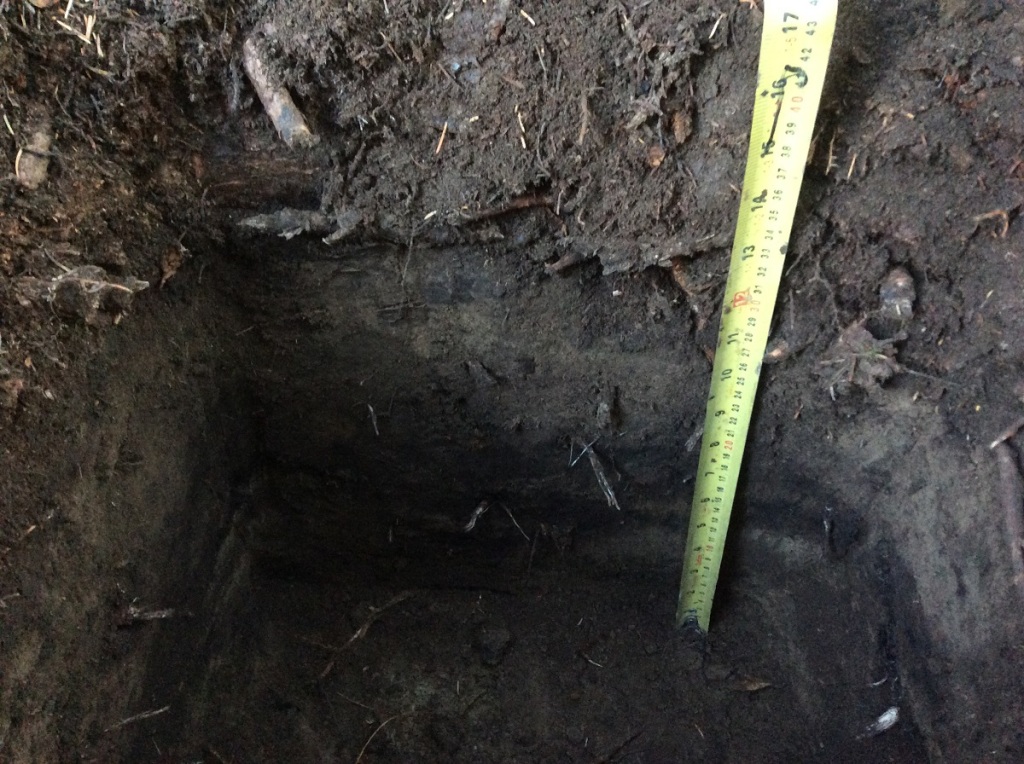
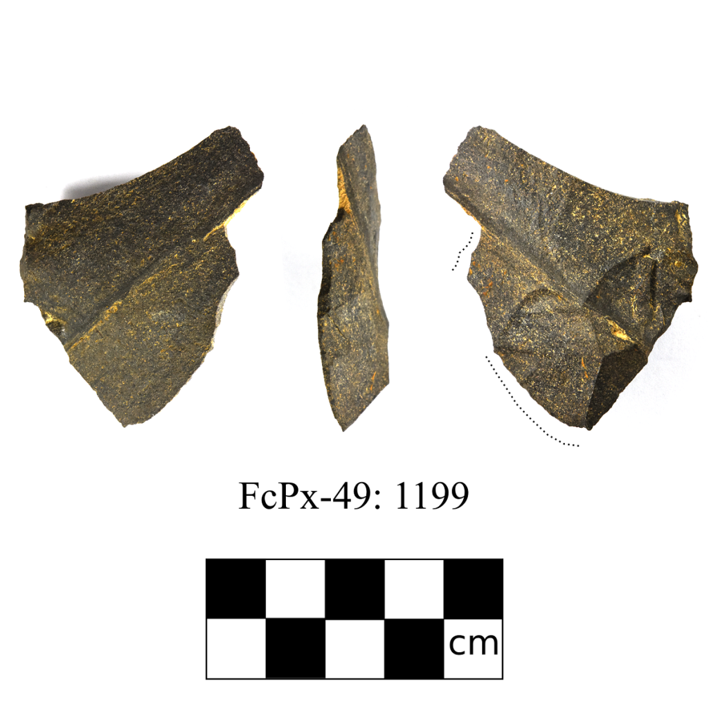
Kurt however, sometimes likes to test low-lying areas at sites, especially if they are sheltered from the wind. So on his recommendation, I put my last test in the low ground at the back of the bench. We generally focus on high, dry ground, so a low spot such as this is usually assumed to be less likely to have artifacts. After shaking through some dirt, I looked down, and to my surprise there was a projectile point in my screen! If it wasn’t for Kurt’s decision to begin site evaluation, the site would have remained a rather insignificant isolated find. In this case, a small amount of site evaluation allowed us to not only dramatically increase the site’s significance, but also gain more information concerning the site’s age and the activities that had occurred there.

Projectile point found in shovel test in low spot!

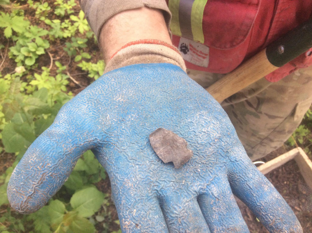
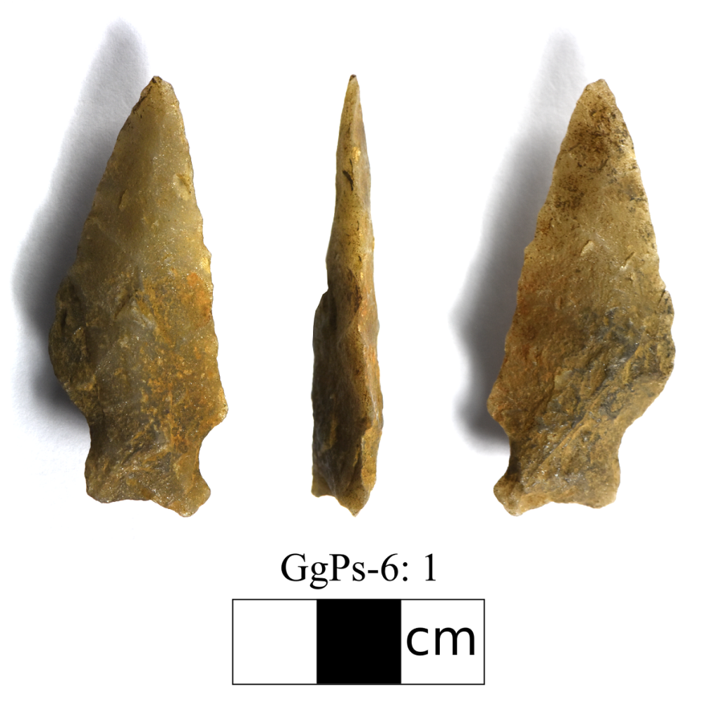
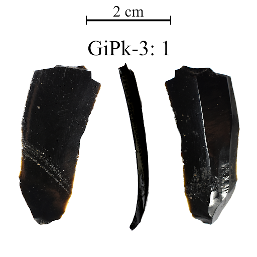
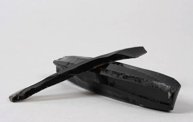
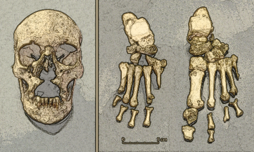
The small siltstone point we recovered, is likely an atlatl dart point and is very similar to Besant-type points (2500 – 1350 years old) found on the northern plains. It is also bears similarities to points belonging to the Late Taltheilei (1300 – 200 years old) tool tradition used by caribou hunters in the Northwest Territories. More archaeological research conducted in the boreal regions of Alberta may provide us a clearer picture of the movements of people in the past, but as of now our knowledge of past cultural interactions is somewhat limited. Artifacts from sites such as this, increase our understanding of past lifeways and provide data for future research.

Besant atlatl point (2,500-1,350 years before present)

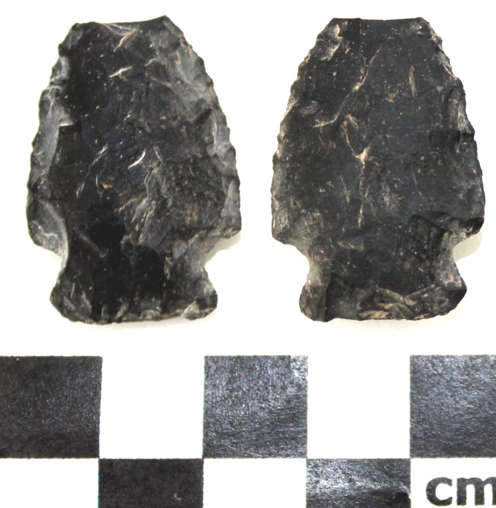
It is interesting to note that the tip of the dart point is missing. The tip of the point may have been accidentally broken off during its production or re-sharpening, but it could have also been broken during use. Point tips regularly break off when they hit something hard in flight, such as bone, a tree or a rock. This point missing its tip is an interesting example of the continued use of a landscape for a specific purpose.

This knoll, which is currently someone’s hunting spot, was also used for hunting over a thousand years ago. Alberta alone has over 40,000 registered archaeological sites, and this number grows every year. There is a good chance that ‘sweet spot’, which you use for camping, hunting or fishing, has been used repeatedly throughout the past and will be continued to be enjoyed by future generations. Next time you are out and about, take a minute to think about how we share the land with past peoples and how our landscape shapes the human experience. If you happen to discover archaeological material at your favorite spot, be sure to inform the Government of Alberta so that it can be properly protected for future generations!

Flakes like these may reveal an archaeological site at your favorite spot!

Cecily Margaret Guido (Peggy Piggott)

Books and movies, like The Dig (author John Preston and director Simon Stone), reintroduce us to people in our archaeological history that have either been forgotten or downplayed by societal norms of the time. They encourage us to dig into the past to discover who these people were, and how they contributed to the advancement of our field. Cecily Margaret Guido, or Peggy Piggott, as she was known at the time of the Sutton Hoo excavations in 1939, was in the right place at the right time. She discovered the first item of the large collection of artifacts from the famous ship burial. But this was was such a small snippet of a long and productive career. Peggy was a very busy woman!

Lily James plays Peggy Piggott in the new film The Dig

Margaret Guido (b. August 5, 1912, d. September 8, 1994) was an English archaeologist known for methods, field-leading research into prehistoric settlements, burial traditions, and artifact studies. Her career spanned sixty years, and was defined by high field standards, and rapid, high-quality publications. At the time of the Sutton Hoo discovery in 1939, she was already an accomplished archaeologist with plenty of fieldwork experience, and not as inexperienced or “bumbling” as portrayed in the The Dig. In 1933 she excavated under the tutelage of Mortimer and Tessa Verney Wheeler, at the Roman town, Verulamium (Hertfordshire, England). In 1934 she earned a “diploma” from the University of Cambridge, as they did not award degrees to women at the time. By 1936, she had completed a post-graduate diploma from the Institute of Archaeology in London, where she focused on Western European Prehistory. In 1937, at the age of 25, she directed an excavation at the Latch Farm (Hampshire) Middle Bronze Age barrow and urnfield cemetery, wrote up the excavation of an Early Iron Age site at Southcote (Berkshire), and published a study on the pottery from Iron Age Theale. In 1938-39 she worked on research excavations at the Early Iron Age site of Little Woodbury (Wiltshire), and published the results of work conducted at the Early Iron Age site at Langton Matravers (Dorset).

Original photograph by Barbara Wagstaff © Trustees of the British Museum, digital image © National Trusthttps://www.nationaltrust.org.uk/blogs/archaeologists-blog/personal-reflections-on-the-digs-and-discoveries-at-sutton-hoo

In July 1939, Guido and her then husband, Stuart Piggott, arrived at the Sutton Hoo location to aid Charles Phillips, who had assumed control of the excavations under the British Museum, the Office of Works, Cambridge University, Ipswich Museum, and the Suffolk Institute. On July 21, not long after her arrival at site, Guido had discovered the first of 263 items that confirmed the ship was a burial mound, and that the Anglo-Saxon Dark Ages were in fact a rich cultural period.

https://en.wikipedia.org/wiki/Sutton_Hoo_helmet

Over the next two decades, Guido’s work forged her into one of the most important British prehistorians. She conducted extensive excavations at six hillforts, excavated for the Ministry of Works during WWII, and produced approximately fifty publications for British Prehistory which advanced the fields of Bronze Age burial traditions, Late Bronze Age artifact studies, Later Bronze Age and Iron Age settlement studies (especially roundhouse architecture and hillfort chronologies). Later in her career she produced the definitive texts on Prehistoric, Roman, and Anglo-Saxon glass beads that are still used today. By the age of 32 she was elected a Fellow of the Society of Antiquaries of London due to her contributions to the study of British prehistory. In 1987 she was President of the Wiltshire Archaeological and Natural History Society, a position she held until her death at the age of 82.

Her work on hillfort studies (both field methods and interpretations) are some of the most influential work on the understanding of early British prehistory. In 1948 she excavated Hownam Rings, Hayhope Knowe in 1949, and Bonchester Hill in 1950, and published the results within the same year. The field methods she used at Hayhope Knowe was a combination of the best parts of the Wheeler and Bersu schools of excavation, but modified to allow for quick assessment. This was the first time these were used on northern Iron age sites. As a result, in one season Guido was able to open 520 sq. m in targeted open-area trenches, which were used to investigate three houses and their enclosure sequence.

Hayhope Know Excavation map – Fig. 9 from “The Iron Age Settlement at Hayhope Knowe, Roxburghshire. Excavations 1949. By C.M. Piggott, Proceedings of the Society of Antiquaries of Scotland, 1951.

Hownam Rings became the type-site for hillfort development, known as the Hownam Paradigm. The paradigm indicated that the progressing complexity of enclosures (pallisade to multivallate earthworks) also represented complexity of cultural development. This paradigm remains valid to this day. Guido also used this site to discuss for the first time the problems of archaeological survival, slope erosion, and the vestigial nature of timber features. She also tested and refined the CBA model, allowing her to provide a relative chronological framework for later prehistoric settlement in southern Scotland. This was a major leap for prehistoric studies in the days before the use of radiocarbon dating became prevalent.

In the later part of her career in the 70s and 80s, Guido focused on researching ancient British glass beads. Her first volume covered both prehistoric and Roman period beads, and the second volume (published posthumously by Martin Welch in 1999) on Anglo-Saxon beads. She co-founded the Bead Study Trust (in 1981), and the Peggy Guido Fund for research on beads. Both volumes remain the primary reference works on the topic.

If you want to read more about the works of Margaret Guido, check out the following links!

https://peoplepill.com/people/margaret-guido/

https://trowelblazers.com/raising-horizons-queens-of-the-castles/

https://en.wikipedia.org/wiki/Margaret_Guido

Gear Review: Bug Nets

Working in the boreal forest as an archaeologist can be difficult for several reasons, but one of the biggest annoyances is the swarms of bugs during the summer months. On a typical day, we encounter black flies, mosquitoes, horse flies, and no-see-ums. Unlike in the province’s urban areas, the bugs in the forest are much more numerous and very relentless and can bite through clothing and gloves. Protection against bugs is essential to keep your sanity intact.

We reviewed various bug shirts below based on the following five factors:

  • Affordability – Archaeologists are not exactly flush with cash, and the cost associated with replacing gear is something to consider.
  • Durability – Working in the boreal forest can be rough on gear. Broken branches and dense underbrush can rip bug nets.
  • Breathability – In the summer months, we often get temperatures over 30 degrees. The breathability of the bug protection is vital to make sure you don’t overheat.
  • Protection – Some bugs can bite through the mesh and even some fabrics. How well does it protect against bites and stings?
  • Visibility – For an archaeologist, visibility is crucial. Whether moving through the bush or spotting an artifact in a screen, the bug net needs to allow the archaeologist good visibility.

The Original Bug Shirt is my personal favorite. It has a black mesh that is very easy to see through. The fabric that lines the arms doesn’t allow bugs to bite through it, and it stands up well to the boreal forest. One of the drawbacks of the Original Bug Shirt is the price, which can range from $70 – $105; however, it doesn’t need to be replaced that often due to the high durability. A second drawback is the net’s breathability, which can become very hot during the summer months.

The Bushline Bug Blocker Pullover jacket is very similar to the Original Bug Shirt but differs in two ways. First, the price is lower than the Original Bug Shirt and costs $45.00. Second, the mesh used for the face is much more challenging to see through than the Original Bug Shirt mesh. I often found when I was looking for artifacts in my screen, I would have to open the net to have a thorough look.

The Coghlan’s Bug Jacket is much cheaper than either of the above options but doesn’t offer the protection they offer. Bugs can bite through the mesh, and the forest can rip holes into it as well. Although, I have seen co-workers wear this bug net under their clothes, so the hood pops out, which is a good work-around. The visibility is better than the Bushline but not as good as the Original Bug Shirt. With this mesh, the sun will glare off it, and I often have to position my body, so the sun isn’t hitting it.

The Pocket Mosquito Head Net is the cheapest option to go with, but it offers the most limited protection. I recommend wearing a hat when using this net to ensure the mesh is away from your face. I find I have the same visibility issues with this mesh as the Coghlan net, which can have a glare if the sun hits it. This net offers no protection for the rest of your body.

“If you move another step towards me, I’ll blow you to hell!” The story of Fort Whoop-Up and Whisky Trading Forts of Southern Alberta

Figure 1: View of Fort Whoop-Up in 1881 (c) Wikimedia Commons

In the 1860s, Southern Alberta was home to several American whisky trading posts that sold liquor and guns to the local Indigenous groups in exchange for bison robes. These transactions occurred despite the United States Law of 1832 that banned liquor sales to the Indigenous groups. One such fort was Fort Hamilton (Later renamed to Fort Whoop-Up), established by John Healy and Alfred Hamilton in 1869 on a traditional camping spot of the Kainai. Although they had a successful first year, the fort was burnt down by the Kainai when the traders were prepping to leave for the summer.


Figure 2: Members of the Kainai Nation outside Fort Whoop-Up (c) Wikimedia Commons

Healy and Hamilton built a second, more elaborate fort the following year in 1870. The fort was only active in the winter when furs were most valuable. The traders would be there for eight months and then head back to Fort Benton in Montana for four months. The local Indigenous groups would set up camps outside the fort, where they would gamble, race horses, and drink the (usually watered-down) liquor they acquired from the fort. These groups were the Kainai, Piegan, and Siksika. These Blackfoot speaking people referred to the fort as akaisakoyi or “many dead” in their language. This name refers to the many conflicts between the white men at the fort and the Natives, but also approximately 70 died from alcohol related deaths (poisoning, passing out in the snow, etc.)

These conflicts were predominantly between the American wolf-hunters (Wolfers) and the Blackfoot. Due to these conflicts, the fort was renowned as a dangerous place by travelers in the region. Reverend John McDougall recalled stopping near the fort to eat when “several men rode out and surrounded them. The men were drunk and had just come from fighting with the Natives. One was all shot up and looking for a doctor.”

The animosity between the two groups stemmed from the Wolfers practice of sprinkling poison on bison carcasses and return to collect wolf hides to sell at the fort. This was not seen as honorable by the Blackfoot, but it also had unintended consequences of killing people and their dogs if they did not know the Wolfers poisoned the carcass. Sometimes the Blackfoot would follow the Wolfers and steal the wolves before the Wolfers would return, often leading to violence.

Figure 3: Inside Fort Whoop-Up (c) Glenbow Archives

Of particular concern to the other white traders in the Whoop-Up region was rumours certain forts were selling repeating rifles to the Blackfoot when only single shift muzzleloaders were allowed. A posse called the “Spitzee Calvary” of around 30-40 men were formed by John Evans and Harry “Kamoose” Taylor to travel to each fort and force the traders to sign an agreement at gunpoint and often took furs and supplies as a fine. When the approached John Healy, now running the nearby Fort Kipp, Healy welcomed them into the cramped trading room:


“guilty and you be damned. What right have you to come down here and try me. You’re a mad dog among a pack of decent hounds. They were good men until you (Evans and Taylor) got among them.” Healy pulled out a shotgun and leveled it at the men. “If you move a foot. If you move another step towards me I’ll blow you to hell!” In another version of the story, he held a lit cigar over an open powder keg. There are various accounts of this incident; some suggest it happened at Whoop-Up and others suggest it happened a Fort Kipp. I did some digging, and Healy clarifies that it happened at Fort Kipp in a 1903 issue of the journal Forest and Stream.

Figure 4: NWMP in 1878 at Fort Walsh, James McLeod sat centre (c) Wikimedia Commons


In response to the stories of violence, the illegal liquor sales, and rumours an American flag was being flown at Fort Whoop-Up, the North West Mounted Police were formed to clean out Whoop-Up. When they arrived in October 1874 after three months of hard travel on the plains, their leader, James MacLeod, set up his men expecting a battle but only found a man with a wooden leg, Dave Akers, and a few Blackfoot women. Exhausted from the long march and frustrated that Healy and Hamilton were nowhere to be found, the NWMP asked for whiskey, but Akers let them know they had none. MacLeod and his men thoroughly searched the entire fort, upstairs, downstairs, in every hole and crevice but could not find any whiskey.

After the NWMP cemented their presence in the region, illegal whisky trading declined, and an NWMP barracks was eventually established at Fort Whoop-Up. The NWMP presence continued until the barracks were burned down in 1888, and the NWMP ultimately abandoned in 1890.

Figure 5: Modern recreation of Fort Whoop-Up that can be visited in Lethbridge, AB. (c) Wikimedia Commons

A modern recreation of the fort can be visited in Lethbridge. Follow this link to learn more about Fort Whoop-Up and plan your visit.

Source:

Fooks, Georgia Green (1983). Fort Whoop-Up : Alberta’s First and Most Notorious Whiskey Fort. Whoop-up Country Chapter, Historical Society of Alberta.

The 9 types of Medicine Wheels in Alberta


Figure 1: Aerial view of the Majorville Medicine Wheel (Courtesy of Alberta Environment and Parks)

Most people are familiar with Medicine Wheels, either from popular culture or books such as “Canada’s Stonehenge” by Gordon Freeman. Many people might not know that while they are found all over the Northern Plains in Montana, Wyoming, and Saskatchewan, they are most numerous in southern Alberta. There are currently 57 documented medicine wheels in Alberta.

Figure 2: View of Majorville Medicine Wheel from the ground (Courtesy of Alberta Environment and Parks)

For those unfamiliar with medicine wheels, they are configurations of stone with at least two of the following: a central cairn, one or more concentric stone rings, or two or more radiating lines from the central cairn. Frequently, there are several other stone features present at the site, including hearths, tipi rings, anthropomorphic figures, and secondary cairns.

The term “medicine wheel” was first used in an issue of Forest and Stream, referring to the Bighorn medicine wheel located near Medicine Mountain in Wyoming. Since then, the term has become a basic generic category. But within this basic category are nine subgroups, which are discussed in further detail below.

Figure 3: Subgroup 1 Medicine Wheel (adapted from Brumley 1988)
  • Type: Subgroup 1
  • Description: Central cairn surrounded by a stone circle.
  • # in Alberta: 24
  • Discussion: Typically found on high hills away from significant water bodies where high frequencies of glacial till are present (Brumley 1988). The presence of these types of medicine wheels on high peaks may result from the proximity to cobble and boulder-strewn moraine, which was used in the construction of the rock feature (Peck and Wetzel 2018). As for function, small artifacts and religious paraphernalia within cairns suggest ceremonial locations.
Figure 4: Subgroup 2 Medicine Wheel (Adapted from Brumley 1988)
  • Type: Subgroup 2
  • Description: Central cairn surrounded by a stone circle but includes a “passageway.”
  • # in Alberta: 5
  • Discussion: These medicine wheels are similar to Subgroup 1 with the exception of the passageway. These types of Medicine Wheels are found on high hills and low terraces near waterbodies. Of the five medicine wheels observed in Alberta, there is no consistency in terms of the passageway’s orientation.


Figure 5: Subgroup 3 Medicine Wheels (Adapted from Brumley 1988)
  • Type: Subgroup 3
  • Description: Central cairn with two or more radiating lines out from the centre.
  • # in Alberta: 5
  • Discussion: In 1880, John McLean observed the construction of a Subgroup 3 Medicine Wheel while at Fort McLeod and noted, “Several great battles were fought, and these cairns were placed to commemorate these events and probably where great warriors died” (McLean 1896: 579). This explanation is similar to the ethnographic descriptions for Subgroups 4 and 7 Medicine Wheels, and all may have served a similar function but vary stylistically.
Figure 6: Subgroup 4 Medicine Wheel (Adapted from Brumley 1988)
  • Type: Subgroup 4
  • Description: A stone ring that has two or more stone lines extending outward from its margins.
  • # in Alberta: 16
  • Discussion: In contrast to Subgroup 1, these are typically found on prairie surfaces along major river valleys or central portion of a river valley bottom or, in other words, typical camp locations (Peck and Wetzel 2018). Ethnographic evidence (Kehoe and Dempsey 1956) suggests these medicine wheels mark where a prominent Blackfoot leader died or was a favorite camp location of the leader. These types of medicine wheels’ location make sense when considering the areas they are found, although some are located on high hills back from waterbodies. What the radiating lines mean is debated, but all agree it is an indication of the Chief’s status that died. While one informant that spoke with Dempsey suggested the lines point to the direction of the warpath the Chief went to war, another informant suggested they are directions from which people would come to feast with the great leader (Kehoe and Dempsey 1956). Although both informants may be correct, and functions may have shifted over time.
Figure 7: Subgroup 5 Medicine Wheel (Adapted from Brumley 1988)
  • Type: Subgroup 5
  • Description: A stone ring that is dissected into segments by four or more interior stone lines radiating outward from a central origin point.
  • # in Alberta: 1
  • Discussion: Archaeologists have only recorded one in Alberta (Jamieson’s Place Medicine Wheel, EePi-2). This subgroup is similar in style to the subgroup 6 Medicine Wheel. According to researchers at the site, it is possible there was a central cairn at the site but was destroyed due to vandalism (Thorpe 1982). If that is the case, it would be reclassified as a subgroup 6 Medicine Wheel.
Figure 8: Subgroup 6 Medicine Wheels (Adapted from Brumley 1988)
  • Type: Subgroup 6
  • Description: A central stone cairn surrounded by a stone ring, two or more interior stone lines that connect the stone ring to the cairn.
  • # in Alberta: 1
  • Discussion: The only Subgroup 6 Medicine Wheel recorded in Alberta is Alberta’s most famous Medicine Wheel, Majorville Carin and Medicine Wheel. Located on a high hill overlooking the Bow River valley, the wheel has 27 badly disturbed stone lines that extend from the central cairn. Archaeologists excavated the southern half of the cairn in 1977 (Calder) and discovered that the central cairn was constructed over 5000 years in accretional domes. Analysis of the 17,000+ artifacts recovered suggests the cultural practice originated from 3200-2500 BCE and continued to be used uniformly until around 1000 BC. Use of the cairn decline until about 200 AD when use picked up again until European contact. The artifacts recovered include ceremonial artifacts and utilitarian artifacts (tools, flakes, cores, etc.); however, these utilitarian artifacts may have been offerings for success in the hunt.
  • Archaeastronomy: While some astronomical orientations are present at the site, there is not enough evidence to confirm if these alignments were intentional or merely an accidental coincidence. This evidence would have to come from oral or written sources or see consistency between the similar Medicine Wheels. Additionally, some astronomical alignments suggested at Majorville incorporate glacial till likely deposited naturally.
Figure 8: Subgroup 7 Medicine Wheels (Adapted from Brumley 1988)
  • Type: Subgroup 7
  • Description: A central stone cairn surrounded by a stone ring, two or more interior stone lines that connect the stone ring to the cairn.
  • # in Alberta: 3
  • Discussion: These medicine wheels are similar in style and locations Subgroup 3 and 4 Medicine Wheels. One Subgroup 7 Medicine Wheel, Many Islands Medicine Wheel, was excavated in 1983. Over 2000 artifacts recovered but mostly represent campsite activities with an emphasis on a lithic workshop of Swan River Chert (Brumley 1988). A lithic workshop’s presence reinforces that the medicine wheel was likely constructed at the campsite location of the Blackfoot, where a leader died.


Figure 10: Subgroup 8 Medicine Wheels (Adapted from Brumley 1988)
  • Type: Subgroup 8
  • Description: A central stone cairn and ring, two or more lines extend outward from the cairn and pass through the wall before terminating.
  • # in Alberta: 0 (2 in Saskatchewan)
  • Discussion: Could be a variation on Subgroups 3, 4, and 7 but limited information.


Figure 11: Subgroup 9 Medicine Wheels (Adapted from Reeves and Kennedy 2018)
  • Type: Subgroup 9
  • Description: Two double circles with four or more spokes terminating just outside the outer ring.
  • # in Alberta: 1
  • Discussion: This is a recently added subgroup (Reeves and Kennedy 2018), based on a type first identified by Deaver (1987). This type of medicine wheel is found at the Grassy Bend Medicine Wheel (DgPc-6), located along the Milk River. The double circles may represent a smaller lodge erected within a a more extensive lodge for ceremonial purposes (Reeves and Kennedy 2018).

Top 10 Sites of 2019!

We are heading into the fall of 2020 and the season crunch is in full swing! We have been pretty busy, despite the challenges of COVID-19, and have found quite a few new and exciting sites. This makes us recall the sites of 2019! It was hard to make time to write up what we found in 2019. Although we find over 100 sites every year, these sites stand out either because we found interesting artifacts or the site is unique in some way.

Locations of the Top Ten Sites of 2019

GgPs-6: Found while assessing a proposed cutblock for Vanderwell Contractors near Swan Hills, AB. The site is located on an irregular ridge surrounded by muskeg and set back from a small lake. At this site we found an asymmetrical projectile point made of quartzite. The projectile point doesn’t fit any of the established diagnostic styles known in Alberta, but could possibly be a hafted knife similar to this knife we found back in 2014.

FgPw-21: Found while assessing a proposed cutblock for Weyerhaeuser Pembina Timberlands near the Brazeau Reservoir. The site is located on prominent hill surrounded by muskeg. At this site we found a small biface made of purple quartzite and a utilized Knife River Flint flake. The biface appears to have been resharpened in the past and was likely once much larger. The tool was likely discarded once the flintknapper felt the tool became exhausted and unusable. The flake of Knife River Flint, is an exotic material that comes from a source in the Dakotas. Along the sharp edges of the flake, small chips we call utilization scars or wear was observed. Sometimes all a person needs is a sharp flake to get the job done!

GgPs-10: Found while assessing a proposed cutblock for Vanderwell Contractors near Swan Hills, AB. The site is located on an irregular knoll overlooking muskeg to the south. Usually we find 1-10 flakes in shovel test, which we interpret as hitting the periphery of a flintknapping scatter likely associated with a single tool production event. Sometimes we get a positive test with 30-50 flakes in a shovel test and feel we hit the knapping area dead-on. If multiple lithic materials are present it likely represents various tool production events. But at this site we hit a full-on lithic workshop! We recovered four hammerstones, five cores, and a total of 7888 flakes!

GiPk-3: Found while assessing a proposed cutblock for Vanderwell Contractors near the Fawcett River. The site is located on a small knoll located southwest of the river and overlooking a wetland to the south. Although we only found one artifact at this site, it is a very interesting tool. The tool is a portion of an obsidian flake made using microblade core technology. The blade has some utilization wear along the lateral edges, as indicated in the picture above. As we have discussed before, obsidian is a volcanic glass and each volcano has a unique chemical signature that allows us to trace where the artifact material came from. We were able to zap this specimen with the pXRF and discovered this obsidian came from over 1700 km from Mount Edziza in British Columbia!

FiPx-5: Found while assessing a proposed cutblock for Blue Ridge Lumber near Niton Junction, AB. The site is located on a long ridge that comes to a high point in the southeast. At this site we found a 90 m long site with flakes, cores, and one ugly projectile point. The projectile point might represent an aborted point that the flintknapper discarded. One of the lateral edges and the one of the notches are broken off, which may represent an error during tool production which resulted in the tool being discarded.

FiPx-2: Found while assessing a proposed cutblock for Blue Ridge Lumber near Niton Junction, AB. At this site we found lithic debitage, two cores and one bone awl. The bone awl is somewhat degraded and the point is not very sharp, but it appears to have been sharpened into a point at one end. The awl would have been used to pierce and mark materials such as leather and wood.

GdPu-19: Found while assessing a proposed cutblock for Blue Ridge Lumber near Swan Hills, AB. The site is located on a low southeast facing edge overlooking a relict oxbow. Although we didn’t find much lithic debitage at this site, we found two hearths (old campfires), 54 pieces of faunal remains (animal bones), and lots of charcoal. Two of the animal bones have indicators of human modification in the form of cutmarks, polish, and spiral fractures. The charcoal from both hearths and the calcined bone were all sent away for radiocarbon testing and received dates of: Charcoal Calibrated AD (1495-1650 AD); calcined bone Calibrated AD (1681-1937 AD). While not very old, this site is interesting in that it was occupied just prior to European Contact in Alberta!

FcPx-39: Found while assessing a proposed cutblock for Sundre Forest Products near Nordegg, AB. The site is located on a west-facing terrace overlooking Dutch Creek. At this site, we found a beautiful siltstone biface preform. Much like GiPk-3 and other sites where we only find one formed tool, these sites likely represent a tool being dropped or lost by hunter or flintknapper.

FcPx-50: Found while assessing a proposed cutblock for Sundre Forest Products near Nordegg, AB. This site is located on a series of rolling hills overlooking the North Saskatchewan River. At this site we found one biface and 15 pieces of lithic debitage. The biface is made from Red Deer Mudstone, also known as Paskapoo Chert, is a material we do not find often. Additionally, we also found one piece of obsidian which was sourced to Bear Gulch, Idaho.

FcPx-49: Found while assessing a proposed cutblock for Sundre Forest Products near Nordegg, AB. This site is located on a large prominent ridge located back from a deeply-incised stream. At this site we had 12 positive tests over 170 x 75 m area. In these positive tests, we found one siltstone biface, two cores, one animal bone, and over 1000+ flakes. Several of the flakes also showed signs of utilization wear.

What’s in Your Bag?

Gear choice can have a big effect on your comfort level and efficiency while working in the forest. New workers, may have never been in the field and may not know what you really need to take for a full 12 hour day in the boreal forest. We expect to spend the entire day away from motorized vehicles so we need carry in everything needed for the day by hand, backpack, or vest. And if you don’t want to feel like your carrying around the kitchen sink, you need to be very selective in what you pack!

There are three basic categories I have on me at all times: archaeological (A), safety (S), and personal (P). The archaeological items are what I need to do the job. The safety are what I need to stay safe, and to meet the OHS Regulations in Alberta. The rest is what I need to enjoy/tolerate my day. These are not always mutually exclusive. For example, I need a radio to communicate with co-workers about the survey we are doing, but also in case of an emergency.

Time of year is also a factor. In spring, crews have encountered snow, rain, and sun all in the same day. Changing weather conditions may allow some items to be dropped, but other things, such as warm gloves, may need to be added. I never leave my rain gear behind, and also carry a survival kit and warm clothes, just in case I end up stranded overnight in the bush.

Load bearing equipment is an important consideration. I personally wear a True North Vest, but others may prefer a more traditional cruise vest. Many companies produce quality backpacks, but not all companies have the same level of warranty. Companies such as Osprey, make a durable lightweight backpack and fully stand behind their product with a stellar warranty. I prefer a 35-45 litre backpack as this size pack fits nicely inside our screens and gives me room for all my gear with a bit of extra space to put extra layers as the temperature rises. Make sure that you get a bag with a rain-cover. Most good bags come with one.

Keep in mind that I generally carry more stuff than most people, but I like to be prepared and don’t mind the weight. Adjust gear accordingly, and try to decide whether you really need something or not.

Things In My Vest

IMG_20200429_130349
All of this fits into the various pockets of the TrueNorth vest. A combination of safety and archaeology specific equipment.

  • iPad Mini (A, S)
    • Tethered to a Bluetooth GPS we use this for data collection, navigation, safety documentation.
  • In-Reach/Bluetooth GPS (A, S)
    • Emergency satellite communication device that increases the accuracy of the iPad’s location.
  • Handheld GPS (A, S)
    • Navigation, important waypoints (truck, quads etc.) data backup (shovel test locations).
  • VHF Radio (A, S)
    • Communication with co-workers and other crews. Great for notifying other nearby workers of hazards, or when we found a site!
  • Compass (A, S)
    • Navigation and orienteering. GPS are notoriously bad at telling you which way is north.
  • Tape measure (A)
    • Measuring shovel test depth. Scale for photography.
  • Pen and Sharpie (A)
    • Always need writing implements
  • Artifact Bags and Tags (A)
    • For  storing artifacts and labeling them with their provenience.
  • Gloves (S)
    • I keep the gloves I am using in my vest. Screening destroys gloves fast so I keep extras in my bag.
  • Multi-tool (S, P)
    • I keep my multi-tool in my vest so I have quick access to it if the need arises.

Things In My Bag:

IMG_20200429_131601
Definitely more than in the vest! Many of these is “just in case” items we hope we won’t need, but could safe your life if conditions change. They are useless if they are left in the truck 3 hours away.

  • Water (S, P)
    • Bladder for hiking and Nalgene bottles for lunch and reserve. I find that I go through a lot of water, but may leave some at the quad if I know I will not need it. Very import to have extra if it is hot outside!
  • Food (S, P)
    • Enough food for the day and a little extra just in case you have to spend the night in the forest. I usually have 3 or 4 Cliff Bars squirreled away somewhere.
  • Knife (A, S, P)
    • Never go into the bush without one. Check out this blog if unsure about which type of knife is best to have.
  • Bear Spray (S)
    • Should never go into areas with bears undefended. It is always a good idea to have a Bear Awareness training before wandering into their backyard. I attach the holster to my bag when on the ATV, but put it on my belt when hiking.
  • Rain Gear (S, P)
    • I never leave my rain gear behind even if the forecast looks good. Our weather is too unpredictable and I rather have it and not need it, than need it and not have it.
  • Head lamp
    • Small, lightweight form of illumination. It can get dark quick in the fall, and it sucks stumbling around the forest in the dark.
  • First Aid Kit (S)
    • Everyone at Tree Time Services Inc. carries a Type P (Personal) first aid kit and supervisors carry a Type 1.
  • Neck Brace (S)
    • I never ever want to have to use this! I will carry it regardless as it could be the difference between life and death.
  • Survival Kit (S, P)
    • I carry a small survival kit with some basic supplies just in case. I don’t plan on having to survive for more than a night without help. It all fits in a Nalgene, which keeps it waterproof. Bonus extra water container! It includes:
      • Extra knife
      • Mirror
      • Whistle
      • Small bundle of paracord
      • Fire starter
      • Bic lighter
      • Water purification tablets
      • Small plastic sheet
      • Cliff bar
  • Extra Clothes/Gloves (S, P)
    • Never know when you may need extra dry clothes or an emergency thermal layer. Extra warm clothing is useless wet, so I keep it dry bags. I bring:
      • Lightweight thermal baselayer
      • Extra warm gloves
      • Socks
      • Extra Bama socks
      • Buff or neckwarmer
      • Lightweight belaclava
        • Particularly important for cold quad rides
  • Bug Spray/Sunscreen (S, P)
    • For when the bugs get bad and the sun is out!
  • Toilet paper (P)
    • No explanation needed. Unless you really want the full nature experience of using leaves and moss.
  • Axe file (A, P)
    • For sharpening shovels and trowels. I hate a dull shovel. Most people sharpen at the truck and leave the file behind.
  • Trowel (A)
    • I usually only bring this on excavation jobs.
  • Bungie-cord (A, P)
    • I use this to attach my screen to my backpack.

Other Items:

  • Cellphone (S, P)
    • (Not pictured) I always keep my phone sealed in a ziplock bag and secured in my vest so that it cannot get damaged or lost.
  • Portable battery charger and Extra Batteries (A, S, P)
    • Can’t do much if our electronics don’t work
  • Flagging (A, S)
    • Always need multiple different colors of flagging for marking hazards, shovel tests and flagging site buffers.
  • Bug net (S, P)
    • Most people will carry a bug net either in their vest or bag depending on how much they use it. Bugs in the boreal can get pretty terrible at times.
  • Collapsible hand saw (A, S, P)
    • For clearing trails or roots out of test pits

Along with all of this we also need to carry a screen and shovel! Most people attach the screen to their backpack and everyone has their preference of shovel. Check out these shovel reviews (Grizzly vs. King of Spades, Bulldog spades) to determine what type you may like best! Enjoy your summer and happy hiking!

What Projects Need HRA Approval, or “Clearance”?

As Consulting Archaeologists, most of our work supports “regulatory compliance”.  We help developers get government approval by assessing and mitigating potential impacts to historic resource sites.  I’m frequently asked by developers whether a specific project requires Historical Resource Act Approval (or “Clearance”, as it was known before 2012).

This isn’t as easy a question as one might think.  Different projects have different levels of impact, and not every development requires approval.  Guidelines for developers are spread across numerous Bulletins and buried in the Instructions for Use of the Listing of Historic Resources.  To make life easier, I thought I’d try to summarize these rules in one place.  Please keep in mind that HRA regulations are constantly changing, so this is a snapshot of the state of the system in spring 2020. If you know of another trigger, or a development class I’ve missed, please let me know.

Alberta Culture uses a variety of triggering mechanisms.  The key tool for determining HRA Requirements is the Listing of Historic Resources.   The Listing was originally developed as a screening tool for small-scale oil and gas.  In response to requests from industry and regulatory agencies to provide more transparency and certainty, Culture is moving towards using the Listing for a wider range of developments. 

Parcels of land are registered on the Listing with a Historic Resource Value (HRV).  HRVs are ranked from 1 through 4  for known sites, or 5 for lands believed to contain a site (high potential).  Each entry on the Listing also has a class, which represents the type of resource.  Historic resources can include archaeological sites, paleontological sites, Traditional Land Use Areas, and historic buildings.  (You can read more about different types of resources here).  There are still many areas of Alberta that have historic resources potential that are not included in the Listing.  This is only one of of the many tools used during the screening process.

DeerMountain_HRV.jpeg
An example of the Listing of Historic Resources from Deer Mountain, near Swan Hills.  Red are HRV 4a (lands containing known sites). Yellow are HRV 5a (lands likely to contain sites). 

According to the Listing Instructions, there are several types of development that always require an application for HRA Approval:

  • Any project that requires an Environmental Impact Assessment (EIA): These applications generally result in a requirement for a Historical Resources Baseline Assessment.
  • Any project that requires National Energy Board (NEB) or Alberta Utilities Commission (AUC) Approval
  • Forest Harvest Plans: These can be managed through the special Forestry HRA Compliance process.  This is Tree Time’s specialty. Contact me before submitting an Application in OPAC.
  • Class 1 Pipelines
  • Projects requiring Conservation and Reclamation Approval by Alberta Environment. According to the Conservation and Reclamation Guidelines for Alberta this includes:
    • The construction, operation or reclamation of a well, battery, oil production site, pipeline, transmission line, telecommunication system, mine, pit quarry, peat operation or plant.
    • The conduct or reclamation of an exploration operation for coal or oil sands;
    • The construction or reclamation of a roadway
    • The reclamation of a railway
  • All Area Structure Plans and other long-term municipal planning documents.

Some development types use the Listing to selectively trigger requirements for HRA Approval:

  • Small-scale conventional oil and gas developments (wellsites, pipelines, access roads, etc)
    • HRA Approval is required if the footprint overlaps any HRV Listed lands.
  • Surface Materials (sand, gravel, clay, peat, etc. pits):
    • 5 ha or larger / Class 1 Pits: HRA Approval is always required.
    • Under 5 ha / Class 2 Pits: HRA Approval is required if the project area overlaps HRV 1, 2, 3 or 4 lands (known sites).
  • Subdivisions:
    • Most subdivisions: HRA Approval required if the project area overlaps any Listed lands (HRV 1-5).
    • Simple subdivisions (first parcel out, 80-acre split, lot / line boundary adjustment or parcel consolidation): HRA Approval required if the project area overlaps HRV 1, 2, 3, or 4 lands (known sites), but not HRV 5 (high potential).
  • Oil Sands and Coal Exploration operations (drilling programs and associated clearing, access and reclamation): HRA Approval required if the project footprint overlaps any Listed Lands (HRV 1-5).
  • Geophysical Programs (seismic): HRA Approval Required if the project footprint overlaps HRV 1, 2, 3 or 4, (known sites) but not HRV 5 (high potential).
  • Geotechnical exploration operations(drilling programs, including those in support of other projects). HRA Approval Required if the project footprint overlaps HRV 1, 2, 3 or 4, (known sites) but not HRV 5 (high potential).
  • Pipeline Integrity Digs (and similar operations, including all access, workspace, laydown, etc). HRA Approval Required if:
    • The activities will extend off the original disposition footprint, and overlap any Listed lands (HRV 1, 2, 3, 4 or 5), or
    • Any activities are on HRV 1, 2, 3, or 4C lands, even if they’re limited to the existing footprint.
  • Utility Distribution Services (including power, low pressure gas, and water supply projects that aren’t triggered by the EIA, NEB, or AUC processes): HRA Approval Required if:
    • The project footprint overlaps HRV 1, 2, 3, or 4 lands (known sites), or
    • The project footprint overlaps HRV 5 lands (high potential) and involves trenching on undisturbed land (eg. native prairie or forest).

Several other Regulatory processes trigger a review of the Listing and fall under the general Instructions for use of the Listing:

“In the absence of a Land Use Procedures Bulletin specific to the proposed project type and/or industry, the proponent must submit a Historic Resources (HR) Application”

  • Public Lands Dispositions:
    • the LAT (Landscape Analysis Tool) reviews all applications against the Listing and notes a Condition (2060) requiring HRA Approval for any dispositions in HRV 1, 2, 3, or 4 lands (known sites).
    • Dispositions not covered by the Bulletins above, such as miscellaneous leases (MLL), and licenses of occupation (LOC) may also be referred for HRA Approval for HRV 5 lands by approvals officers.
  • Water Act Applications: the Wetland Application Checklist requires submission of the results of a Historical Resources Act “Search”. Any developments that involve significant ground disturbance and overlap Listed lands (HRV 1-5) should be submitted for HRA Approval.
  • Temporary Field Authorization: The TFA Application form requires applicants to check the Listing and requires HRA Approval for all Listed lands (HRV 1-5).
  • Biophysical Impact Assessments: Some municipalities (eg. Calgary) include a check of the Listing, or a requirement for HRA Approval, as part of a Biophysical Impact Assessment.

Generally speaking, any development or activity should be referred to Alberta Culture for HRA Approval if it is:

  1. Located in Listed lands (HRV 1-5), and
  2. Involves disturbance of native prairie or forest, or deep excavation

If you don’t know where to start, or would like someone to review your project before you submit it to Culture, contact me (Kurt) or one of the team at 780-472-8878 or toll free at 1-866-873-3846. You can also email us at archaeology@treetime.ca. We’re happy to help!

No volcanoes in Alberta, so where does the Obsidian come from?

When working close to an obsidian source (i.e. volcanoes), archaeologist will regularely find obsidian tools and debitage. However, in the boreal forests of northern Alberta, obsidian is a rare find indeed. So to find any evidence of it at all is pretty significant. Volcanic glass, or obsidian, is one of the sharpest naturally occurring materials on earth. It is sometimes used by surgeons who require a cutting edge that is much thinner and sharper than a stainless steel scalpel. Not only is obsidian extremely sharp, but it is also relatively easy to flint knap and is used by many beginners trying to learn this ancient skill. These features made obsidian a highly valued knapping material.

Pre-contact peoples fashioned various tool types from it, such as knives, projectile points, or composite tools. One method of knapping obsidian was blade core technology. This method involves preparing an obsidian core so that a series of small blades can be removed. This method minimizes the amount of material that is wasted and allowed people to quickly reproduce blades that were a similar size and shape. These blades were then hafted to a bone or stick to create a cutting utensil. To create larger tools, obsidian would have been knapped using normal methods as well.

Obsidian blade and core
Photo credit: B. Bernard

Last summer, Tim and I were surveying some forestry cutblocks at the base of the southern slopes of the Marten Hills, east Slave Lake. During the screening process, I had targeted a series of small knolls that overlooked a muskeg. These knolls were close to the headwaters of the Fawcett River, where a natural pass would have allowed people to easily traverse through the hills. Tim and I walked to the top of the highest knoll and started digging test pits.

Brian at GiPk-3 - Copy
Brian at the GiPk-3 hill top

We were completely shocked when my first test contained an obsidian blade. At this point we were extremely excited, and were sure that we had just found a crazy site. However, even though we dug 40+ test pits, we never found another artifact. The site turned out to be an isolated find. Nuts!

obsidian blade

So if there are no volcanoes in Alberta, where did this obsidian blade come from? Luckily, advances in technology allowed us to quickly solve this question. During his Master’s degree, Tim obtained a license to operate a pXFR analyzer (portable X-Ray Fluorescence), so Tree Time Services Inc. rented one of these devices. Other obsidian artifacts recovered by Tree Time services were all found to come from south of the U.S. border. However, the results of Tim’s analysis suggests that the blade was made of obsidian from Mt. Edziza, British Columbia.

pXRF
Results of pXRF, showing range for various volcanic sources.

That means that this piece of stone had been transported/traded by Pre-contact peoples over a distance of 1700 km! At 10 km travelling distance in a day (on foot), that is 170 days, or almost 6 months. Mt. Edziza obsidian has never been found in the Lesser Slave Lake region, however is is somewhat common in the Peace Region in northwest Alberta. GiPk-3 represents one of the furthest known Mt Edziza obsidian finds from its source. Although Tim and I were disappointed that we didn’t find more artifacts, this single find provided evidence for trade networks that spanned vast distances long before European contact.

Edziza to GiPk-3
Image Credit: Todd Kristensen

Infectious Diseases in the Archaeological Record

COVID-19 has now been designated a global pandemic and continues to spread throughout the world. Not getting infected with this potentially lethal virus is at the forefront of many peoples minds, and the very real possibility of extended quarantine has led to shortages of items such as toilet paper, disinfectant and non-perishable food.

While this may seem like a novel experience to most, pandemics are not new to the human condition and have occurred many times throughout history. However, acute illnesses such as the common cold, the flu, or smallpox, are difficult to study in the archaeological record, since they do not leave any visible signs of infection on skeletal remains. These infections have a rapid onset, and those infected by them usually either recover or perish before the disease has a chance to affect their bones.

On the other hand, chronic infections have a slower onset and may last long enough for a person’s skeleton to show signs of the condition. Tuberculosis, leprosy, and syphilis are three infections that were quite common in some populations and are visible in the archaeological record. These diseases can last months to years, and without modern treatments, people can be plagued with these horrendous conditions for the duration of their lives. Although we may think of them as a part of history, these three infections continue to affect people that do not have access to modern healthcare.

Syphilis


Syphilis_2_mono
Photo Credit: original courtesy of @medicalmuseion; sketch photo credit: @nagerna

Syphilis is caused by Treponema pallidum pallidum, which is a spiral-shaped, mobile bacterium. The infection is sexually transmitted (STI) and has several stages. This infection is sometimes fatal if left untreated and the bacterium can also be transmitted from pregnant women to their unborn children. While not all those with the bacteria will show symptoms (latent syphilis), usually within the first months of exposure, infected individuals will begin to experience skin lesions and rashes.

Syphilis_1_mono
Photo Credit: original courtesy of The College of Physicians of Philadelphia Digital Library

If left unchecked, the infection will spread throughout the body and sometimes cause massive sores, which may eat away the cranial bones. It is commonly speculated that during the 1500’s, endemic syphilis contributed to the rise in popularity of the powdered wig. Useful for controlling lice populations, powdered wigs were also used to cover up the hair-loss and unsightly sores experienced by those suffering from late stage syphilis.

Leprosy

Leprosy, which is Greek for ‘scaly skin’, has been recognized by humans for thousands of years, but its cause was poorly understood. An infection of Mycobacterium leprae or Mycobacterium lepromatosis causes the condition known as Leprosy (a.k.a. Hansen’s Disease). These bacteria destroy nerves throughout the body, causing infected persons to slowly lose their ability to feel pain. Early symptoms include pale or red rashes on skin, hair loss and numbness. As the disease progresses, secondary infections usually lead to disfigurement of the hands, feet and face.

Leprosy_hands&feet_mono
Photo credit: original courtesy of The British Academy; sketch photo credit: Professor Eileen Murphy, Queen’s University Belfast

The transmission of leprosy is still not fully understood, but is generally believe to be passed via the respiratory tract, not via skin contact, which was commonly believed prior to the modern era. Leprosy is usually contracted by close contact with an infected individual, or as the result of living in poverty in tropical climates where the bacteria is naturally prevalent. It is also possible for the bacteria to pass from animals to humans and vice versa, and the leprosy-causing agent has been found in both red squirrels and armadillos.

Most people that are in contact with the bacteria do not contract leprosy, and mothers cannot pass the bacteria to unborn children. However, there is a long history of social stigma attached to leprosy, and in some areas, afflicted individuals are still forced to reside in ‘leper colonies’. The word leper’ is now considered a derogatory term.

Tuberculosis

Tuberculosis (TB) is a primarily a pulmonary disease caused by an infection of Mycobacterium tuberculosis bacteria. Like leprosy, TB has been around since ancient times, and was referred to as ‘phthisis’ in ancient Greece and ‘consumption’ in English speaking areas throughout history. While TB is primarily an infection of the lungs, it can spread to other regions to the body and can cause identifiable damage to the bones of afflicted individuals.

Spinal TB_mono
Photo credit: original courtesy of Hungarian Natural History Museum. Creator: Hajdu, Tamás and Évinger, Sándor. Contributor: Szőke, Béla Miklós and Évinger, Sándor

TB is thought to have originally been transmitted to humans from bovines (cows), and can be passed to humans from close contact with the animals, or consuming meat and unpasteurized milk products. One of the oldest known instance of tuberculosis is from a 17,000 year old bison skeleton. However, TB can also be transmitted from humans to cattle, so it is unclear whether the bacteria is originated in bovids or humans. In humans, the bacteria is transmitted via pulmonary aerosols similar to COVID-19. Also similar to COVID-19, TB is an opportunistic infection and is usually more severe in people with compromised immune systems. Approximately 90% of infected people will experience no symptoms, but if symptoms do develop, 50% of afflicted individuals will die without proper treatment.

A vaccine for TB does exist. However, once symptoms arise, a lengthy treatment using multiple antibiotics is the only cure. Recently there has also been an increase in drug resistant strains of the bacteria, which are much more difficult to treat. Today, TB remains to be one of the most deadly infectious diseases in the world. It is estimated that roughly 1/4 of the world’s human population is infected by the bacteria, and that it causes approximately 1.5 million deaths annually.

Historical Diseases are not History

The long history of these diseases is visible in the archaeological record, yet these afflictions themselves are not history. We may think of leprosy as a medieval, or ancient syndrome, but the truth is that people still suffer from this horrendous diseases. Even though these conditions are treatable, the antibiotics needed are expensive and many people simply do not have access to them. Donate to reputable charities such as, Doctor’s Without Borders, if you wish to help fight these terrible infections.